

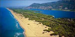
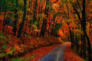
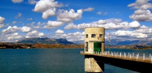
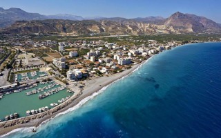
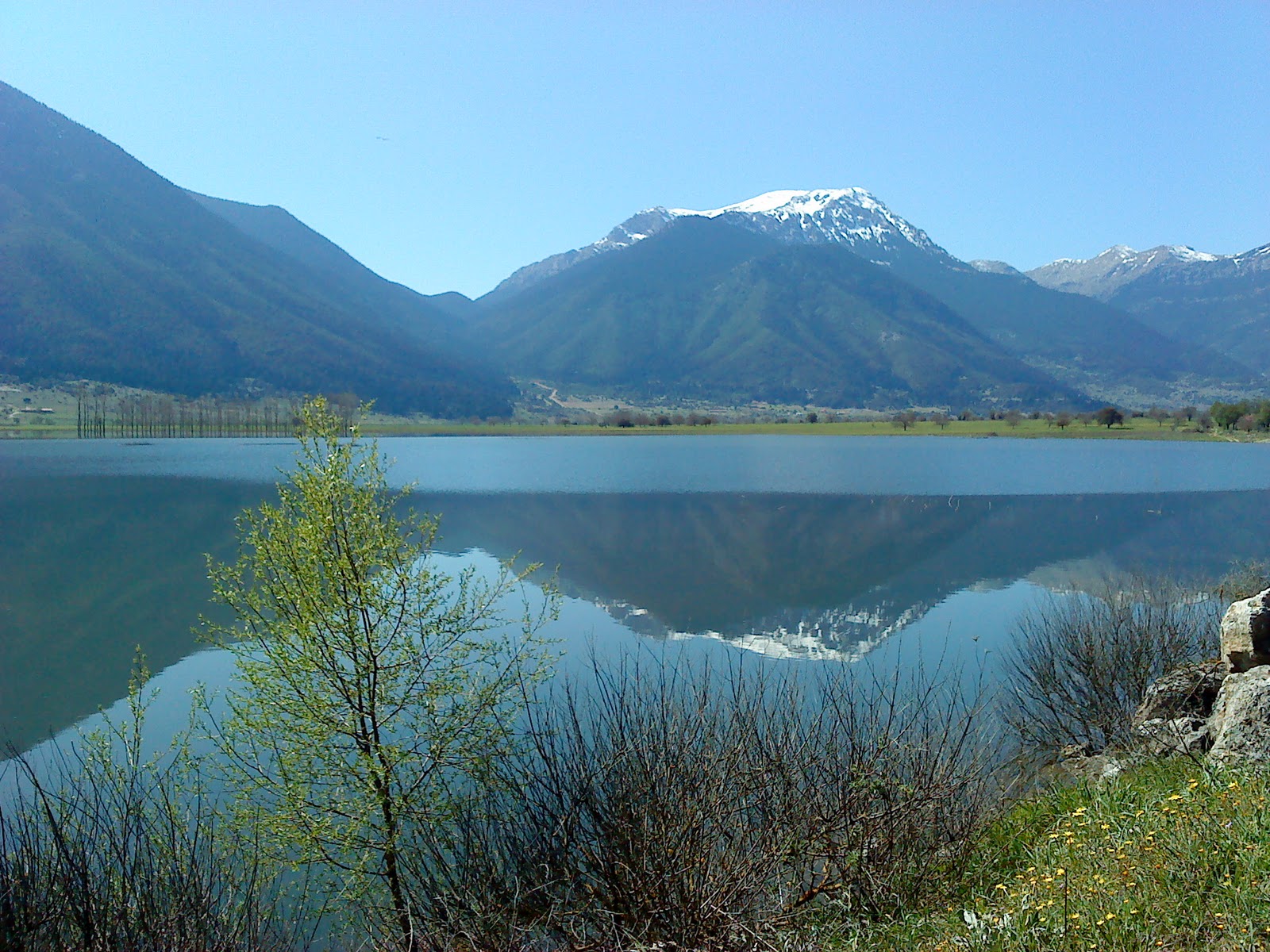
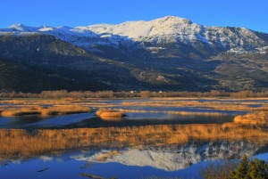
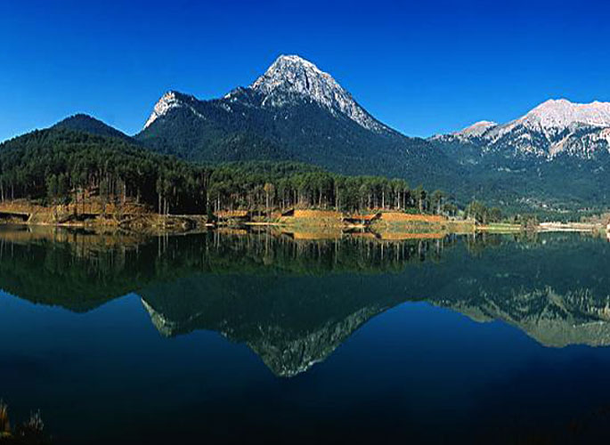
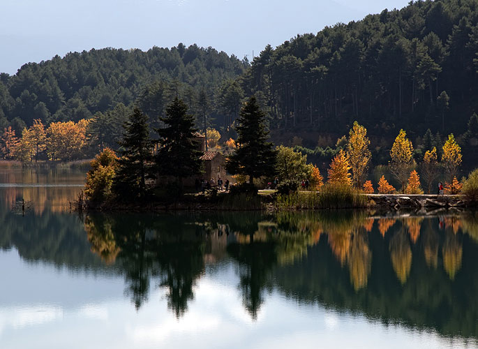
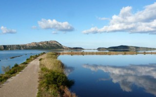
 To the west of the prefecture of Ilia, 27 km from its capital, Pyrgos, lies the area known as Kaiafas, comprising a vast beach on the side of the Ionian sea, a coastal pine forest and the homonymous lake, which is the centre of health tourism in the area. The healing properties of the Kaiafa lake waters have been known since antiquity; according to the ancient Greeks, they owed their properties to the nymphs who inhabited the forests surrounding the area. For that reason they honoured them with great piety, erecting splendid temples and sanctuaries in their name. Those visiting Kaiafas today do so not only for the water therapy, but also to admire the unique natural landscape and to do activities such as sea sports, which are offered in the area. The beautiful, serene nature also sets the scene for total relaxation, away from the city’s rapid pace.
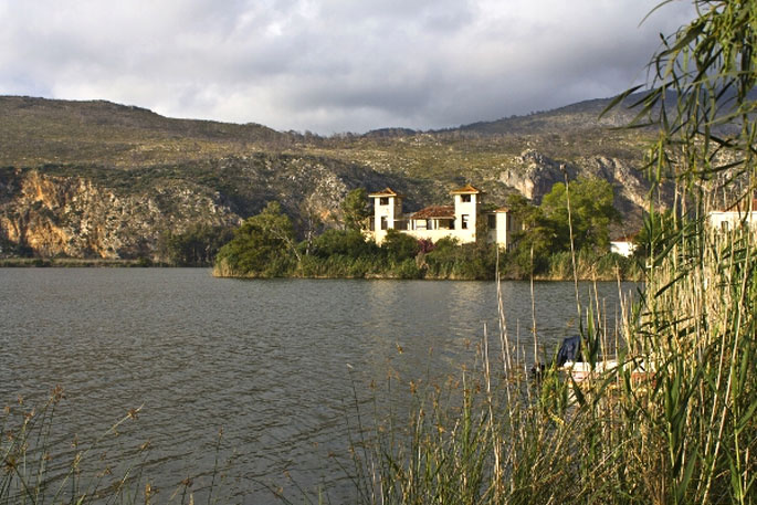
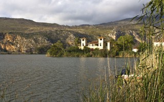
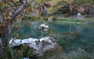
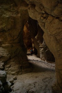
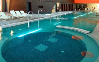
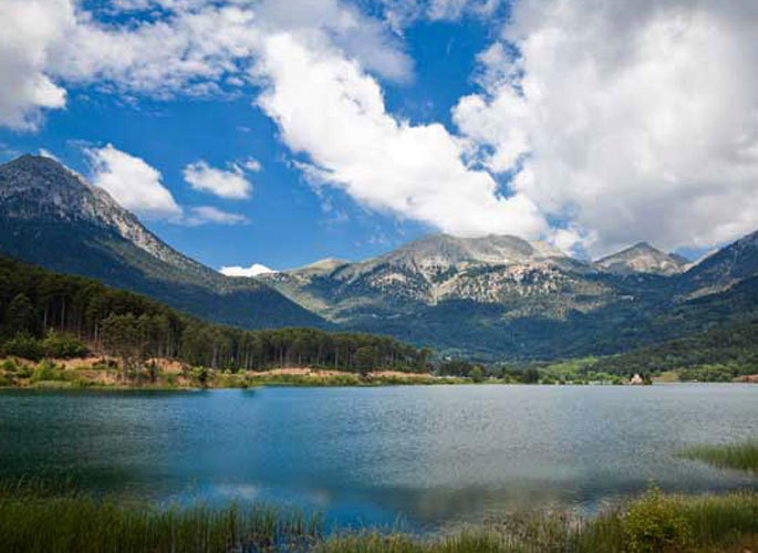
 Kaiafas, with its lake and the unique natural landscape that surrounds it, is located on the border with the Municipality of Zacharo and comprises the huge, sandy coast traversing the entire coastal line of the bay of Kyparissia, the impressive pine forest of Strofilia, the plain of Xirochori-Zacharo and the mountain range of the mythical mountain Lapithas, on the western foot of which lies the spring of the Anigrides nymphs and on its eastern foot the spring of Geranios.The warm, healing waters of the lake are considered suitable for skin conditions, rheumatism, various conditions of the liver and asthma, and have many times been exalted by those who tried water therapy as a solution to one of the aforementioned problems. The belief in their healing properties is an ancient one; according to Pausanias, the cave that lies to the area’s west, called “the cave of the Anigrides nymphs”, was inhabited by the nymphs Kalliafeia, Pigaia and Iasis. From the first one derives the name of the area today, Kaiafas, while the names of the other two testify to the existence of healing waters (pigi = spring, iasis = cure). According to myth, Dardanos, the ancestor of the Trojans, was born in the Anigrides cave. It is also said that in this spring the Centaur Nessos washed his wounds; he had been hit by the poisonous arrows of Hercules, which explains the waters’ foul smell.
This hydrotherapy centre is responsible for attracting many tourists in the area, of all ages and from all over the world. The healing waters are rich in hydrogen sulphide and their temperature remains stable at 20-30 °C between May and October, which is the most suitable period for water therapy.
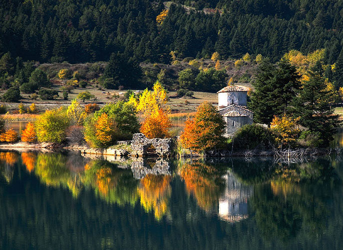
Kaiafas, of cource, isn’t good only for water therapy; many also come here to enjoy the enchanting landscape, with the emerald-green sea, the beach with the sand dunes and the unique vegetation surrounding the lake. It is not a coincidence that the lake has been declared a protected area. At its centre lies the islet of Aghia Ekaterini, with the small church of the same name and the Tourism Development Company’s building facilities, which include, among others, hotels and lodgings. The islet and the opposite coast are linked by a bridge, while the transition from the hydrotherapy centre to the hotel facilities and the reverse is done by boat.
For those who wish to get to know the surrounding area, there are various points of interest, such as the beaches of Kourouta and Zacharo and also other, lesser known beaches, a short distance away by car. No matter what you choose to do, it is certain that your stay in the Kaiafas area will regale you with unique images and offer you moments of complete relaxation.
Source: www.mythicalpeloponnese.gr
Kaiafas
To the west of the prefecture of Ilia, 27 km from its capital, Pyrgos, lies the area known as Kaiafas, comprising a vast beach on the side of the Ionian sea, a coastal pine forest and the homonymous lake, which is the centre of health tourism in the area. The healing properties of the Kaiafa lake waters have been known since antiquity; according to the ancient Greeks, they owed their properties to the nymphs... read more
Ancient Ilida
Ilida or Ilis was a city-state in ancient Ilia, very near ancient Olympia, and took up the area which today extends from the village of Paliopoli (or Nea Ilida) to the southeast, Bouchioti (or Avgeio) to the southwest and Kalyvia to the west. According to myth, it was founded by Oxylus, son of Aemon and Gorgi, who is also mentioned in some traditions as the founder of the Olympic Games. Oxylus, who hailed... read more
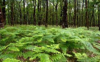
Foloi oak forest
Foloi oak forest is a designated site under NATURA 2000 that dates back to ancient times. It’s the only flat forest in Greece situated on the boundaries between Elis, Arcadia and Achaia, at an altitude of 600meters. It covers a total surface of 218.000 acres and it consists mainly of broadleaf oaks. Foloi oak forest is a designated site under NATURA 2000 that dates back to ancient times. It’s... read more
Pineios River and Pineios artificial lake
Pineios is one of the Peloponnese’s most significant rivers, its total length is 70 km. Also known as Gastouni River, it has its sources in the mount Erymanthos and empties in the Ionian Sea near town bearing the same name. According to mythology, Hercules diverted the flow of Pineios and Alfeios rivers in order to clean the Augean Stables in his fifth labor. After having demolished the stables’... read more
Alfeios
Peloponnese’s longest river (111km long) has its source in Arcadia and its mouth in the Prefecture of Elis. According to mythology, Apheus was one of the river-gods of antiquity, worshiped mainly in the regions of Arcadia, Elis and Messinia. Son of Oceanus and Tethys, he killed his brother Cercaphus and haunted by the Erinyes, he leapt into the river which was later named after him. Source: www.mythicalpeloponnese.gr [vc_row][vc_column][ivi_nbcaj... read more

Ancient Olympia
During classical times Olympia was the city of Ilia best known as the area where the Olympic Games took place, the greatest athletic event of the then-Greek world. Today Ancient Olympia is a village and a municipality of Ilia, built in the valley of river Alpheus. Nearby lies the archaeological site, one of the most popular ones in Greece, which attracts every year tourists from all over the world.... read more
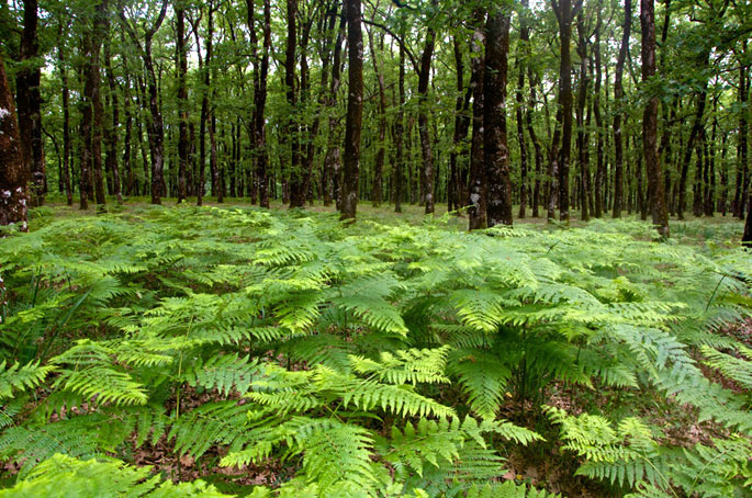
Foloi oak forest is a designated site under NATURA 2000 that dates back to ancient times. It’s the only flat forest in Greece situated on the boundaries between Elis, Arcadia and Achaia, at an altitude of 600meters. It covers a total surface of 218.000 acres and it consists mainly of broadleaf oaks.
 Foloi oak forest is a designated site under NATURA 2000 that dates back to ancient times. It’s the only flat forest in Greece situated on the boundaries between Elis, Arcadia and Achaia, at an altitude of 600meters. It covers a total surface of 218.000 acres and it consists mainly of broadleaf oaks.According to mythology, the forest was named after the Centaur Pholus, who gave roof to his friend, Hercules, on his way to locate the Erymanthian Boar. Pholus offered Hercules a divine wine which excited the rest of the Centaurs who attacked the two friends. During the battle, Pholus was injured by mistake from one of Hercules’ arrows. The hero decided then to name the forest Foloi after his friend.
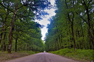 In antiquity, the plateau of Foloi was covered by a dense plantation; namely, oaks, pines, kermes oaks, strawberry trees etc. as well as wild animals such as wolves, deer, boars, foxes, francolins, woodcocks, and numerous other species. The town of Akroria, Aasion, was situated on the west side of the plateau. The town was completely destroyed by Alarichos in 396 B.C. At the present, a true relic of the past, the oak forest of Filoi with its ancient trees starts in a distance of 15km from the village Lala. Wander into the magnificent forest and admire the breathtaking view to the plain of Alfeios and to the mountains.
Source: www.mythicalpeloponnese.gr
Kaiafas
To the west of the prefecture of Ilia, 27 km from its capital, Pyrgos, lies the area known as Kaiafas, comprising a vast beach on the side of the Ionian sea, a coastal pine forest and the homonymous lake, which is the centre of health tourism in the area. The healing properties of the Kaiafa lake waters have been known since antiquity; according to the ancient Greeks, they owed their properties to the nymphs... read more
Ancient Ilida
Ilida or Ilis was a city-state in ancient Ilia, very near ancient Olympia, and took up the area which today extends from the village of Paliopoli (or Nea Ilida) to the southeast, Bouchioti (or Avgeio) to the southwest and Kalyvia to the west. According to myth, it was founded by Oxylus, son of Aemon and Gorgi, who is also mentioned in some traditions as the founder of the Olympic Games. Oxylus, who hailed... read more
Foloi oak forest
Foloi oak forest is a designated site under NATURA 2000 that dates back to ancient times. It’s the only flat forest in Greece situated on the boundaries between Elis, Arcadia and Achaia, at an altitude of 600meters. It covers a total surface of 218.000 acres and it consists mainly of broadleaf oaks. Foloi oak forest is a designated site under NATURA 2000 that dates back to ancient times. It’s... read more
Pineios River and Pineios artificial lake
Pineios is one of the Peloponnese’s most significant rivers, its total length is 70 km. Also known as Gastouni River, it has its sources in the mount Erymanthos and empties in the Ionian Sea near town bearing the same name. According to mythology, Hercules diverted the flow of Pineios and Alfeios rivers in order to clean the Augean Stables in his fifth labor. After having demolished the stables’... read more
Alfeios
Peloponnese’s longest river (111km long) has its source in Arcadia and its mouth in the Prefecture of Elis. According to mythology, Apheus was one of the river-gods of antiquity, worshiped mainly in the regions of Arcadia, Elis and Messinia. Son of Oceanus and Tethys, he killed his brother Cercaphus and haunted by the Erinyes, he leapt into the river which was later named after him. Source: www.mythicalpeloponnese.gr [vc_row][vc_column][ivi_nbcaj... read more
Ancient Olympia
During classical times Olympia was the city of Ilia best known as the area where the Olympic Games took place, the greatest athletic event of the then-Greek world. Today Ancient Olympia is a village and a municipality of Ilia, built in the valley of river Alpheus. Nearby lies the archaeological site, one of the most popular ones in Greece, which attracts every year tourists from all over the world.... read more
 Pineios is one of the Peloponnese’s most significant rivers, its total length is 70 km. Also known as Gastouni River, it has its sources in the mount Erymanthos and empties in the Ionian Sea near town bearing the same name. According to mythology, Hercules diverted the flow of Pineios and Alfeios rivers in order to clean the Augean Stables in his fifth labor. After having demolished the stables’ walls, the hero used the river flow to clean the dung.
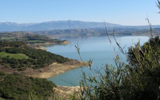
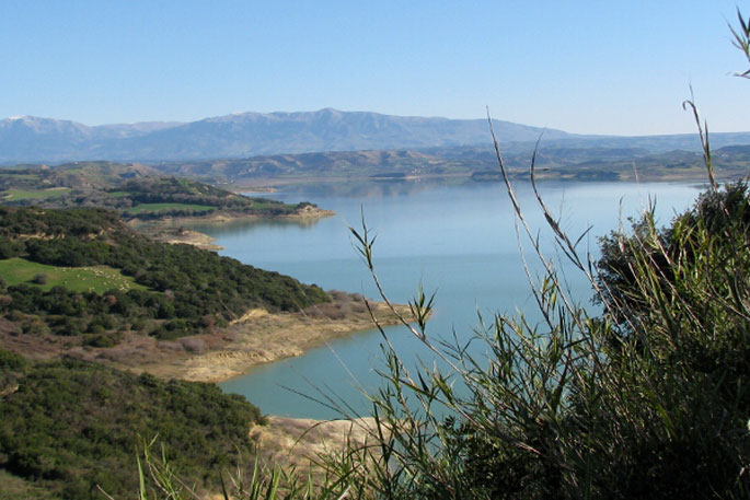
 Pineios River, on its way to the sea, supplies the artificial lake of Pineios. One of Elis most important constructions completed in 1968, the dam that holds the water of the river is located close to Ancient Ilida. Its total height is 50m and it is 2,175 meters long.
Source: www.mythicalpeloponnese.gr
Kaiafas
To the west of the prefecture of Ilia, 27 km from its capital, Pyrgos, lies the area known as Kaiafas, comprising a vast beach on the side of the Ionian sea, a coastal pine forest and the homonymous lake, which is the centre of health tourism in the area. The healing properties of the Kaiafa lake waters have been known since antiquity; according to the ancient Greeks, they owed their properties to the nymphs... read more
Ancient Ilida
Ilida or Ilis was a city-state in ancient Ilia, very near ancient Olympia, and took up the area which today extends from the village of Paliopoli (or Nea Ilida) to the southeast, Bouchioti (or Avgeio) to the southwest and Kalyvia to the west. According to myth, it was founded by Oxylus, son of Aemon and Gorgi, who is also mentioned in some traditions as the founder of the Olympic Games. Oxylus, who hailed... read more
Foloi oak forest
Foloi oak forest is a designated site under NATURA 2000 that dates back to ancient times. It’s the only flat forest in Greece situated on the boundaries between Elis, Arcadia and Achaia, at an altitude of 600meters. It covers a total surface of 218.000 acres and it consists mainly of broadleaf oaks. Foloi oak forest is a designated site under NATURA 2000 that dates back to ancient times. It’s... read more
Pineios River and Pineios artificial lake
Pineios is one of the Peloponnese’s most significant rivers, its total length is 70 km. Also known as Gastouni River, it has its sources in the mount Erymanthos and empties in the Ionian Sea near town bearing the same name. According to mythology, Hercules diverted the flow of Pineios and Alfeios rivers in order to clean the Augean Stables in his fifth labor. After having demolished the stables’... read more
Alfeios
Peloponnese’s longest river (111km long) has its source in Arcadia and its mouth in the Prefecture of Elis. According to mythology, Apheus was one of the river-gods of antiquity, worshiped mainly in the regions of Arcadia, Elis and Messinia. Son of Oceanus and Tethys, he killed his brother Cercaphus and haunted by the Erinyes, he leapt into the river which was later named after him. Source: www.mythicalpeloponnese.gr [vc_row][vc_column][ivi_nbcaj... read more
Ancient Olympia
During classical times Olympia was the city of Ilia best known as the area where the Olympic Games took place, the greatest athletic event of the then-Greek world. Today Ancient Olympia is a village and a municipality of Ilia, built in the valley of river Alpheus. Nearby lies the archaeological site, one of the most popular ones in Greece, which attracts every year tourists from all over the world.... read more

 Peloponnese’s longest river (111km long) has its source in Arcadia and its mouth in the Prefecture of Elis. According to mythology, Apheus was one of the river-gods of antiquity, worshiped mainly in the regions of Arcadia, Elis and Messinia. Son of Oceanus and Tethys, he killed his brother Cercaphus and haunted by the Erinyes, he leapt into the river which was later named after him.
Source: www.mythicalpeloponnese.gr
Kaiafas
To the west of the prefecture of Ilia, 27 km from its capital, Pyrgos, lies the area known as Kaiafas, comprising a vast beach on the side of the Ionian sea, a coastal pine forest and the homonymous lake, which is the centre of health tourism in the area. The healing properties of the Kaiafa lake waters have been known since antiquity; according to the ancient Greeks, they owed their properties to the nymphs... read more
Ancient Ilida
Ilida or Ilis was a city-state in ancient Ilia, very near ancient Olympia, and took up the area which today extends from the village of Paliopoli (or Nea Ilida) to the southeast, Bouchioti (or Avgeio) to the southwest and Kalyvia to the west. According to myth, it was founded by Oxylus, son of Aemon and Gorgi, who is also mentioned in some traditions as the founder of the Olympic Games. Oxylus, who hailed... read more
Foloi oak forest
Foloi oak forest is a designated site under NATURA 2000 that dates back to ancient times. It’s the only flat forest in Greece situated on the boundaries between Elis, Arcadia and Achaia, at an altitude of 600meters. It covers a total surface of 218.000 acres and it consists mainly of broadleaf oaks. Foloi oak forest is a designated site under NATURA 2000 that dates back to ancient times. It’s... read more
Pineios River and Pineios artificial lake
Pineios is one of the Peloponnese’s most significant rivers, its total length is 70 km. Also known as Gastouni River, it has its sources in the mount Erymanthos and empties in the Ionian Sea near town bearing the same name. According to mythology, Hercules diverted the flow of Pineios and Alfeios rivers in order to clean the Augean Stables in his fifth labor. After having demolished the stables’... read more
Alfeios
Peloponnese’s longest river (111km long) has its source in Arcadia and its mouth in the Prefecture of Elis. According to mythology, Apheus was one of the river-gods of antiquity, worshiped mainly in the regions of Arcadia, Elis and Messinia. Son of Oceanus and Tethys, he killed his brother Cercaphus and haunted by the Erinyes, he leapt into the river which was later named after him. Source: www.mythicalpeloponnese.gr [vc_row][vc_column][ivi_nbcaj... read more
Ancient Olympia
During classical times Olympia was the city of Ilia best known as the area where the Olympic Games took place, the greatest athletic event of the then-Greek world. Today Ancient Olympia is a village and a municipality of Ilia, built in the valley of river Alpheus. Nearby lies the archaeological site, one of the most popular ones in Greece, which attracts every year tourists from all over the world.... read more
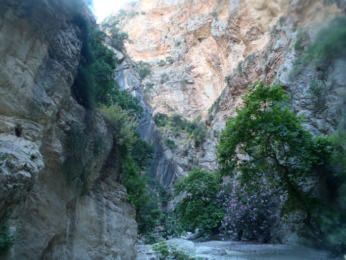
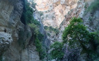
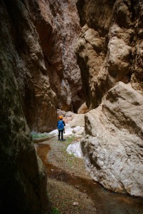 Fonissa is a stream that forms a deep gorge from Vrysoules village to Loutro, in the municipality of Xylokatsro-Evrostini. In antiquity the stream was the natural borders of ancient Pellene, called Krios (ram). The name “fonissa” (female murderer) highlights how dangerous it is to be in its way when it is full of water. The only way to access the gorge is to follow the road from Kato Loutro village towards the monastery of Korfiotissa. Just before the monastery, turn left to the track descending to the stream. In every crossroad, turn in the direction of the antenna on the opposite hill. The track ends at the stream. Once at the dam, take the track that leads to Kato Loutro village.
 It consists of a small yet impressive gorge that offers a trekking route of 10km. It is formed at the point where river that starts from Korfiotissa, is interrupted by a large limestone hill for 1.5 km before it reaches the Cornthian gulf. At some points it gets really narrow, acquiring the characteristics of a cave. It has an average width of 2-3 meters and has limestone hillsides.Fonissa gorge was first made safe in 1984 by Spiros Apostolopoulos and Aris Theodoropoulos. Many other teams have continued the work ever since rendering the gorge safe and accessible. During the spring, water flows in the gorge, while the first narrow point is formed after the entrance. For almost one km (800m) the light gets scarce and the open points are few. The gorge offers 5 technical descendings, the biggest being 18m, and just before the exit the light appears again. Although equipment is required throughout the route, we can walk along it.
Fonissa offers 5 technical descendings, 250m difference in altitude, and 1.5km of length. A four member group requires three hours to cross it.
Source: www.mythicalpeloponnese.gr
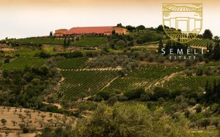
The Semeli Estate, Korinthos
since 1979 “an evolving tradition in winemaking excellence” Founded in 1979, with deep roots in time-honored winemaking traditions and eyes on the future, the Semeli Estate produces wines of exceptional quality offering consumers best value for money. The sunny Mediterranean climate and the extraordinary terroir, combined with the expert craftsmanship of our winemakers and the successful... read more
Centre of History and Science “GRAMMI.org”
The Centre of History and Science "GRAMMI.org" is a new initiative that aims at turning, through its activities, the visit to Corinth to an unforgettable experience. The Centre’s aim is to offer opportunities to visitors to experience, in an innovative, exciting, and interactive way, the importance of Corinth’s history and the scientific and technological achievements connected with it. With... read more
Fonissa Gorge
Fonissa is a stream that forms a deep gorge from Vrysoules village to Loutro, in the municipality of Xylokatsro-Evrostini. In antiquity the stream was the natural borders of ancient Pellene, called Krios (ram). The name “fonissa” (female murderer) highlights how dangerous it is to be in its way when it is full of water. The only way to access the gorge is to follow the road from Kato Loutro village... read more
Marina of Xylokastro
There is a small marina at the eastern end Xylokastro. It has a slightly narrow entrance and it consists of two parts, and it is more likely to find a spot to dock at the internal part. It also has a good dock and offers a satisfactory protection, with the city only 5 minutes away, so you can easily get food supplies. Source: www.mythicalpeloponnese.gr [vc_row][vc_column][ivi_nbcaj layout="5"... read more
Loutraki Thermal Spa
When you are seeking rejuvenation of the body and the soul, the only choice is the method of hydrotherapy at Loutraki Thermal Spa, in the city of Loutraki. Ancient “Thermes” was a well-known market town at the northern groove of the Corinthian Gulf and it is linked to the mythological “Artmemis Thermia”, who was the protector of the thermal springs. The therapeutic powers of the thermal baths... read more
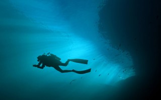
Diving at Corinth
There are many diving schools in Corinthia for those interested in exploring its underwater world. Diving is allowed in the region, except in some specific archaeological sites and sea parks. Fishing with scuba diving equipment is not allowed, including spear guns with oxygen bottles, taking photos or removing antiquities. You can get more information at the local port police stations.Most diving spots... read more
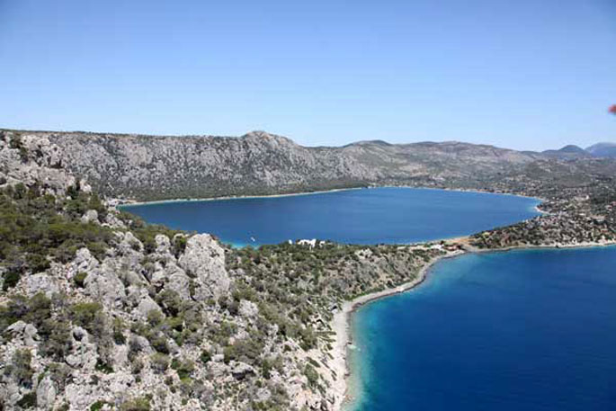
 Vouliagmeni Lake is located west of the Isthmos canal, 16 kilometers from the town of Loutraki, after the village of Perachora and next to the archaeological site of Heraion. In antiquity, it was named Eschatiotis or Gorgopis after Gorgi, Corinthos’s wife, who drowned in the lake after been informed about the murder of her children.
Video by fabdrone
It is a two kilometers wide lagoon and one kilometer long. Its depth reaches 40 meters and it is connected to the Corinthian golf by a narrow channel (width of 6 meters). It is surrounded by a pine forest which forms a magnificent landscape. Early Hellenistic settlements, that date back to 3000 B.C., have been found in the area around the lake.
Source: www.mythicalpeloponnese.gr
The Semeli Estate, Korinthos
since 1979 “an evolving tradition in winemaking excellence” Founded in 1979, with deep roots in time-honored winemaking traditions and eyes on the future, the Semeli Estate produces wines of exceptional quality offering consumers best value for money. The sunny Mediterranean climate and the extraordinary terroir, combined with the expert craftsmanship of our winemakers and the successful... read more
Centre of History and Science “GRAMMI.org”
The Centre of History and Science "GRAMMI.org" is a new initiative that aims at turning, through its activities, the visit to Corinth to an unforgettable experience. The Centre’s aim is to offer opportunities to visitors to experience, in an innovative, exciting, and interactive way, the importance of Corinth’s history and the scientific and technological achievements connected with it. With... read more
Fonissa Gorge
Fonissa is a stream that forms a deep gorge from Vrysoules village to Loutro, in the municipality of Xylokatsro-Evrostini. In antiquity the stream was the natural borders of ancient Pellene, called Krios (ram). The name “fonissa” (female murderer) highlights how dangerous it is to be in its way when it is full of water. The only way to access the gorge is to follow the road from Kato Loutro village... read more
Marina of Xylokastro
There is a small marina at the eastern end Xylokastro. It has a slightly narrow entrance and it consists of two parts, and it is more likely to find a spot to dock at the internal part. It also has a good dock and offers a satisfactory protection, with the city only 5 minutes away, so you can easily get food supplies. Source: www.mythicalpeloponnese.gr [vc_row][vc_column][ivi_nbcaj layout="5"... read more
Loutraki Thermal Spa
When you are seeking rejuvenation of the body and the soul, the only choice is the method of hydrotherapy at Loutraki Thermal Spa, in the city of Loutraki. Ancient “Thermes” was a well-known market town at the northern groove of the Corinthian Gulf and it is linked to the mythological “Artmemis Thermia”, who was the protector of the thermal springs. The therapeutic powers of the thermal baths... read more
Diving at Corinth
There are many diving schools in Corinthia for those interested in exploring its underwater world. Diving is allowed in the region, except in some specific archaeological sites and sea parks. Fishing with scuba diving equipment is not allowed, including spear guns with oxygen bottles, taking photos or removing antiquities. You can get more information at the local port police stations.Most diving spots... read more
 Lake Doxa is located on the borders of Sikyonion municipality, on the plateau of Pheneos. It is an artificial lake, 900 meters above sea level, completed in late 1990 with the construction of the water dam bearing the same name. In the center of the lake, on a narrow strip of land, stands the chapel of Saint Fanourios or Palaiomonastero, the remains of an old monastery that was relocated because of the floods from one of the forested slopes surrounding the lake. The new monastery of Saint George offers a magnificent view to the lake.
Even though it is believed that Doxa Lake is hidden among the mountains, it is easily accessed. Once in village Mossia, take the road to the left that leads to Messino village, pass through Ancient Pheneos, or Kalyvia according to the locals, and you are one kilometer away from Corinth’s small “Switzerland”.
Source: www.mythicalpeloponnese.gr
The Semeli Estate, Korinthos
since 1979 “an evolving tradition in winemaking excellence” Founded in 1979, with deep roots in time-honored winemaking traditions and eyes on the future, the Semeli Estate produces wines of exceptional quality offering consumers best value for money. The sunny Mediterranean climate and the extraordinary terroir, combined with the expert craftsmanship of our winemakers and the successful... read more
Centre of History and Science “GRAMMI.org”
The Centre of History and Science "GRAMMI.org" is a new initiative that aims at turning, through its activities, the visit to Corinth to an unforgettable experience. The Centre’s aim is to offer opportunities to visitors to experience, in an innovative, exciting, and interactive way, the importance of Corinth’s history and the scientific and technological achievements connected with it. With... read more
Fonissa Gorge
Fonissa is a stream that forms a deep gorge from Vrysoules village to Loutro, in the municipality of Xylokatsro-Evrostini. In antiquity the stream was the natural borders of ancient Pellene, called Krios (ram). The name “fonissa” (female murderer) highlights how dangerous it is to be in its way when it is full of water. The only way to access the gorge is to follow the road from Kato Loutro village... read more
Marina of Xylokastro
There is a small marina at the eastern end Xylokastro. It has a slightly narrow entrance and it consists of two parts, and it is more likely to find a spot to dock at the internal part. It also has a good dock and offers a satisfactory protection, with the city only 5 minutes away, so you can easily get food supplies. Source: www.mythicalpeloponnese.gr [vc_row][vc_column][ivi_nbcaj layout="5"... read more
Loutraki Thermal Spa
When you are seeking rejuvenation of the body and the soul, the only choice is the method of hydrotherapy at Loutraki Thermal Spa, in the city of Loutraki. Ancient “Thermes” was a well-known market town at the northern groove of the Corinthian Gulf and it is linked to the mythological “Artmemis Thermia”, who was the protector of the thermal springs. The therapeutic powers of the thermal baths... read more
Diving at Corinth
There are many diving schools in Corinthia for those interested in exploring its underwater world. Diving is allowed in the region, except in some specific archaeological sites and sea parks. Fishing with scuba diving equipment is not allowed, including spear guns with oxygen bottles, taking photos or removing antiquities. You can get more information at the local port police stations.Most diving spots... read more
 Lake Stymphalia is one of the most significant wetlands of Greece in the municipality of Sikyonion. The land is closely related to one of the most popular mythology heroes. Hercule’s sixth feat consisted of killing the Stymphalian birds, the man eating birds with bronze beaks which haunted the lake, with his arrows. According to scientists, the Stymphalian birds were inspired from the Northern Bald Ibis (Geronticus eremita).
It is situated at an altitude of 600 meters on the plateau bearing the same name. It receives the water of the plateau’s springs and the water drained from the plateau of the reclaimed Pellene Lake.It is designated as a landmark for fauna and flora under the EU’s Natura 2000 program.
Source: www.mythicalpeloponnese.gr
The Semeli Estate, Korinthos
since 1979 “an evolving tradition in winemaking excellence” Founded in 1979, with deep roots in time-honored winemaking traditions and eyes on the future, the Semeli Estate produces wines of exceptional quality offering consumers best value for money. The sunny Mediterranean climate and the extraordinary terroir, combined with the expert craftsmanship of our winemakers and the successful... read more
Centre of History and Science “GRAMMI.org”
The Centre of History and Science "GRAMMI.org" is a new initiative that aims at turning, through its activities, the visit to Corinth to an unforgettable experience. The Centre’s aim is to offer opportunities to visitors to experience, in an innovative, exciting, and interactive way, the importance of Corinth’s history and the scientific and technological achievements connected with it. With... read more
Fonissa Gorge
Fonissa is a stream that forms a deep gorge from Vrysoules village to Loutro, in the municipality of Xylokatsro-Evrostini. In antiquity the stream was the natural borders of ancient Pellene, called Krios (ram). The name “fonissa” (female murderer) highlights how dangerous it is to be in its way when it is full of water. The only way to access the gorge is to follow the road from Kato Loutro village... read more
Marina of Xylokastro
There is a small marina at the eastern end Xylokastro. It has a slightly narrow entrance and it consists of two parts, and it is more likely to find a spot to dock at the internal part. It also has a good dock and offers a satisfactory protection, with the city only 5 minutes away, so you can easily get food supplies. Source: www.mythicalpeloponnese.gr [vc_row][vc_column][ivi_nbcaj layout="5"... read more
Loutraki Thermal Spa
When you are seeking rejuvenation of the body and the soul, the only choice is the method of hydrotherapy at Loutraki Thermal Spa, in the city of Loutraki. Ancient “Thermes” was a well-known market town at the northern groove of the Corinthian Gulf and it is linked to the mythological “Artmemis Thermia”, who was the protector of the thermal springs. The therapeutic powers of the thermal baths... read more
Diving at Corinth
There are many diving schools in Corinthia for those interested in exploring its underwater world. Diving is allowed in the region, except in some specific archaeological sites and sea parks. Fishing with scuba diving equipment is not allowed, including spear guns with oxygen bottles, taking photos or removing antiquities. You can get more information at the local port police stations.Most diving spots... read more
Since 1998, a new wetland was formed on the plateau of Pheneos, behind the irrigation dam of the torrent bearing the same name. The plateau of Pheneos is a large triangular flat plateau surrounded by forested slopes. It borders with the prefecture of Achaia to the west and the prefecture of Arcadia to the south. It is the last plateau of the prefecture of Corinthia to the southwest. It is an endless colorful mosaic. The prefecture of Corinthia obtained an open air artificial hydrologic park, surrounded by magnificent landscapes and natural forest ecosystems of special ecological interest. These forests have been included in the Natura 2000 Chelmos project.
Source: www.mythicalpeloponnese.gr
The Semeli Estate, Korinthos
since 1979 “an evolving tradition in winemaking excellence” Founded in 1979, with deep roots in time-honored winemaking traditions and eyes on the future, the Semeli Estate produces wines of exceptional quality offering consumers best value for money. The sunny Mediterranean climate and the extraordinary terroir, combined with the expert craftsmanship of our winemakers and the successful... read more
Centre of History and Science “GRAMMI.org”
The Centre of History and Science "GRAMMI.org" is a new initiative that aims at turning, through its activities, the visit to Corinth to an unforgettable experience. The Centre’s aim is to offer opportunities to visitors to experience, in an innovative, exciting, and interactive way, the importance of Corinth’s history and the scientific and technological achievements connected with it. With... read more
Fonissa Gorge
Fonissa is a stream that forms a deep gorge from Vrysoules village to Loutro, in the municipality of Xylokatsro-Evrostini. In antiquity the stream was the natural borders of ancient Pellene, called Krios (ram). The name “fonissa” (female murderer) highlights how dangerous it is to be in its way when it is full of water. The only way to access the gorge is to follow the road from Kato Loutro village... read more
Marina of Xylokastro
There is a small marina at the eastern end Xylokastro. It has a slightly narrow entrance and it consists of two parts, and it is more likely to find a spot to dock at the internal part. It also has a good dock and offers a satisfactory protection, with the city only 5 minutes away, so you can easily get food supplies. Source: www.mythicalpeloponnese.gr [vc_row][vc_column][ivi_nbcaj layout="5"... read more
Loutraki Thermal Spa
When you are seeking rejuvenation of the body and the soul, the only choice is the method of hydrotherapy at Loutraki Thermal Spa, in the city of Loutraki. Ancient “Thermes” was a well-known market town at the northern groove of the Corinthian Gulf and it is linked to the mythological “Artmemis Thermia”, who was the protector of the thermal springs. The therapeutic powers of the thermal baths... read more
Diving at Corinth
There are many diving schools in Corinthia for those interested in exploring its underwater world. Diving is allowed in the region, except in some specific archaeological sites and sea parks. Fishing with scuba diving equipment is not allowed, including spear guns with oxygen bottles, taking photos or removing antiquities. You can get more information at the local port police stations.Most diving spots... read more
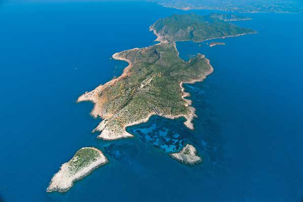
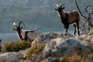
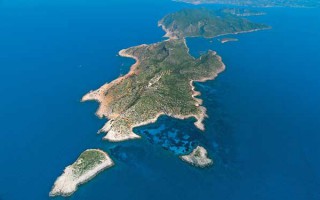
Sapientza is an islet of the Messinian Oinousses cluster and is the second biggest after Schiza. It’s an island with lush vegetation, a rare flora and a total area of 9 square kilometres. In 1986, Sapientza was declared as a “listed natural monument” and it was included in the European Network Natura 2000, together with the neighboring Schiza and the area around cape Akritas.Sapientza in Italian means “wisdom” and, indeed, nature here has revealed all its wisdom. In the center of the island there is a huge area covered with typical Mediterranean vegetation of perennial broadleaf weeds, which however don’t have the usual shape of a bush, but they are trees that surpass 10 meters in height! The fauna of the island is equally interesting and includes the famous Kri-Kri (wild goats) that live here in large herds, as well as wild sheep and many species of birds.
 The islet of Sapientza is located off the southwest shores of Messinia, across from Methoni, and is one of the 7 islands that form the cluster of the Messinian Oinousses. Historically, Sapientza was claimed by many, due to its strategic location -at the crossroads between Italy and the Middle East-, as well as due to its safe harbor. In 1209 it fell into the hands of the Venetians and many centuries later, after the liberation of Greece from the Turks, it was returned to the Greeks. It was claimed by the British, as part of the Ionian Islands between 1847 and 1850, during the notorious “Don Pacifico Affair” that was a conflict between Britain and Greece.
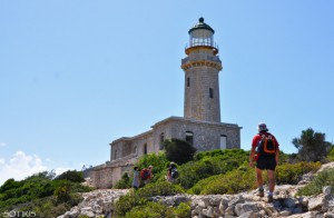
Porto Loggo is the harbor of Sapientza and is a well-protected cove. A trail starts from there, leading to the famous lighthouse of the island, which is an impressive British construction of 1890 with a spectacular view. The famous, unique in Europe, perennial broadleaf forest dominates the center of the island in an area of 240 square metres. This forest was basically the reason the islet was declared as a “listed natural monument” and included in the European Network Natura 2000. The rarity of this forest is that its broadleaf weeds surpass their standard height, creating dense vegetation, which exists there for about 15,000 years!
 In the centre of the island there is a plateau covered by orange-yellow rocks, which was formed by deposits of vast amounts of pollen over thousands of years. This plateau is named Spartolakka and is a substantial source of information for scientists regarding the dating of the forest and the surrounding area. The famous “Well of Oinousses” is located on the southwest side of the island and is actually the deepest point in the Mediterranean at 5,121 metres.
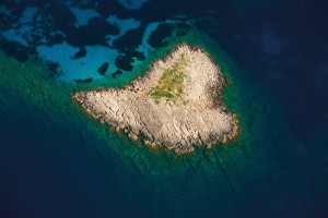 The island has a lovely, well-protected beach, named Ammos, which is located on its northern part and is easily accessible. Findings and traces of shipwrecks were also found on the northern tip of Sapientza and at a shallow depth. The most important one includes the columns from the Grand Peristyle from Caesarea of Palestine, dating back to the first century AD. This exact location, named Cape Karsis, attracts many keen divers due to the interest of the seabed.
Source: www.mythicalpeloponnese.gr
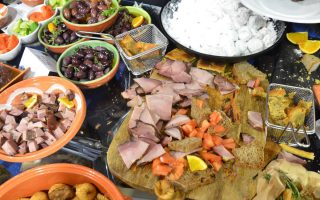
Kalamata Gastronomic Destination
Professionals in the field of gastronomy in its broadest sense – the agricultural sector, processing, hospitality, restaurants – have joined forces and created a society called the Gastronomic Community of Kalamata. Their goal is to enlist the best food-related businesses in the region, to set up a parallel structured link between Tourism and the Gastronomic Culture of Messinia, and to promote... read more
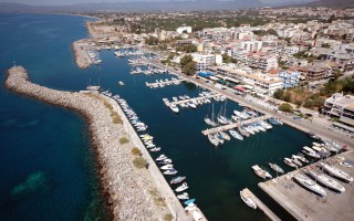
Kalamata Marina
The marina offers a full range of technical services covering a wide range of maintenance and repair works. Kalamata marina is situated in Peloponnesus in Kalamata city on the west of Kalamata harbour in the Messinian Gulf, and is considered by many to be the ideal location to take refuge and rest as it is the passage from the Mediterranean and the Ionian Sea to the Aegean Sea. Kalamata is a modern... read more
Sapientza and the Perennial Broadleaf Forest
Sapientza is an islet of the Messinian Oinousses cluster and is the second biggest after Schiza. It’s an island with lush vegetation, a rare flora and a total area of 9 square kilometres. In 1986, Sapientza was declared as a “listed natural monument” and it was included in the European Network Natura 2000, together with the neighboring Schiza and the area around cape Akritas.Sapientza in Italian... read more
Gialova Lagoon
Gialova lagoon is located in Messinia and is one of the most important wetlands not only in Greece, but also in Europe. It probably dates to prehistoric times and owes its creation both to tectonic activity and to a rise in sea level, phenomena which created this ecological zone of unique importance.The Gialova lagoon is the first station in the Balkans that the migratory birds from Africa come across;... read more
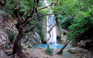
The Gorge of Neda
Neda is the only “female” river in Greece. It stems from the foot of Mount Lykaion and flows into the Ionian Sea, more specifically into the Kyparissiakos Gulf. Neda is approximately 32 kilometres long and passes through a stunning fairytale-like landscape.The Valley of Neda was of particular importance to the ancient Greeks and was often mentioned in various myths, while it is surrounded by archaeological... read more
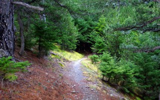
Vassiliki Forest
The forest of Vassiliki is located at the southern part of the Taygetus mountain range, 8 km south of its summit, and has an expanse of approximately 11,000 stremmata. It is a relatively secluded forest, surrounded by summits. You can reach it from Eksochori and there is a road in the forest you can follow for 21 km. Here you will mostly come across fir trees and black pines. During the Italian... read more