

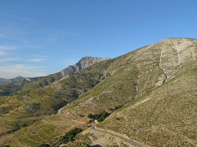
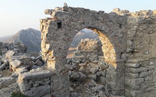
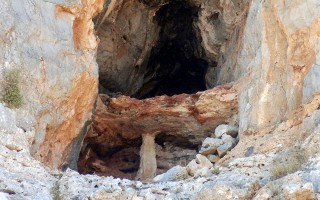
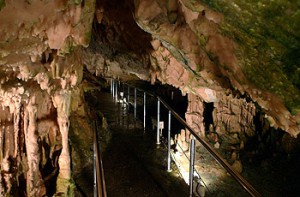
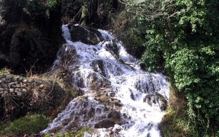
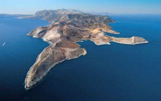
This is the highest peak of Naxos, usually covered with clouds and named Myti of Za (Nose of Zeus). It has namely the name of Zeus and maybe this was also its name in the antiquity, as they used to worship the father of gods on this very mountain. The archaic inscription carved on a rock in the path that leads to the top of the mountain says “Oros Dios Milosiou” (Mountain of Zeus of Milon), which is an evidence that Naxian shepherds worshiped Zeus also as protector of their flocks, “milon” as they called sheep.
The maximum height of the mountain is 1003m. The cave is found at 600m and it is also connected to the cult of Zeus. An arched gate 2.5m high leads to the magnificent interior of the cave consisting of a chamber with 115m length and 75m maximum width.
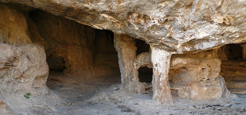
The decoration is rich and involves impressive stalactites and stalagmites, boulders and stone clusters. In the highest part of the cave there are two stalagmites named “Papa” and “Papadia”, as well as the so-called “Agia Trapeza”. The cave was explored in 1962 by Anna Petrocheilou. Excavations carried out in the period 1985-86 and in 1994 brought to light important findings from the neolithic to the classical and Roman times, many of which are exhibited at the Archaeological Museum of Naxos. They have also found tools made of obsidian and vertebrate bones.
Info
– During the Turkish rule, the cave was used as a shelter but also as a church.
– To visit the cave, start from the village Filoti (there are signs). The main part of the route is on foot and you will need to carry strong light torches.
Source: aegeanislands.gr
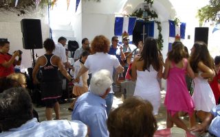
Customs and Festivals of Naxos
Music, dancing with traditional costumes, songs, arts, feasts and festivals are part of the Naxian daily life. The island is famous all over Greece for its rich musical tradition and there are important composers/musicians from Naxos, including Konitopouleoi, Fyrogenides, Stamatonanolides, Vrontogiorgides, Koukoularides, Hatzopouloi. “Kotsakia” (folk poems of two or eight verses that were created... Read more
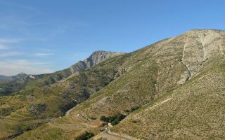
The mount and cave of Zas
This is the highest peak of Naxos, usually covered with clouds and named Myti of Za (Nose of Zeus). It has namely the name of Zeus and maybe this was also its name in the antiquity, as they used to worship the father of gods on this very mountain. The archaic inscription carved on a rock in the path that leads to the top of the mountain says “Oros Dios Milosiou” (Mountain of Zeus of Milon), which... Read more
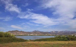
Naxos wetlands
The small wetlands, salt marshes and dunes of Naxos are a haven for birds, fish and reptiles. The most important wetland is that of Alyki which comprises a large lake southwest of the airport runway. It is the largest salt lake in the Cyclades and retains enough water. The vegetation includes reeds, aquatic plants and clumps of cedar trees. 166 bird species have been observed and it is enlisted in the protected... Read more
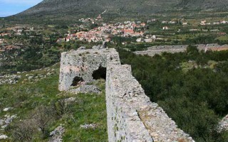
Apaliros castle
This is a very important castle, built on a steep hill in the fields of Sangri and Agiassos. According to researchers, it took its name after the abundant “apaliries”, a kind of bush that sprouts there. It was erected in the first years of the Byzantine era, though probably there was already a fortification in the antiquity, because part of the wall is prehistoric. It was abandoned in the 13th... Read more
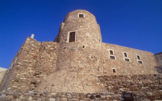
Naxos towers
Today about 30 towers are preserved in the countryside of the island. They have been built by feudal Venetians in particular (and other Latin nobles) who used them as a base to exploit the real estate of the field they held. Their defensive line included battlements, murder holes, turrets, huge doors and small windows to protect the defenders. They were made of stone and had many floors and thick walls. Bazeos... Read more

Gardoumia
Gardoumia is a special meze from lamb intestines that is made on the island of Naxos, just like in Crete; besides, the strong connections between the two islands are well-known. Meze holds a special place in the Greek culinary tradition and could be described as an appetizer, a treat to share with friends in a relaxed environment. Gardoumia is a popular dish among mountain and pastoral farming/shepherds’... Read more
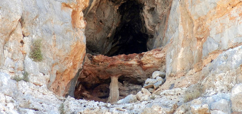
It lies to the North-Northeast of Kato Zakros. We arrive at the cave either after a one-hour walk from Kato Zakros or from the beach of the same settlement by engine-vessel (20-25 minutes) and after that, we follow a tiresome ascending route (15 minutes walk). The elevation at the entrance attains 105 metres. Stones consist of limestones from the upper Cretaceous and of dolomites from the Triassic period. A little more west of the cave there is an elevation called Traostalos (elevation: 515 metres).
Pelekita (“hewn” in English) is the name by which the whole area is known. It comes from the quarry lying underneath the cave, near the seashore, where people used to extract hewn stones from the Meocene marly limestone deposits that exist there. Another name of the cave is Sikias Spilios (“Cave of the Fig Tree), due to the big fig tree that exists on the right side of the entrance under the cave, from where the view to the sea is breathtaking. Pelekita Cave is one of the biggest in Crete. Its total length attains 310 metres.
It has large chambers up to 45 metres in width and quite high. Corridors of a total length of 700 m approximately can be exploited. The cave takes up an area of 500 square metres approx. but if its inclinations are taken into account, the area is much more bigger. The first time it was roughly mapped and studied was by El. Platakis on 11th August 1963. A full mapping of the cave was conducted end of November 1969by members of the Greek Speleological Society led by I. Ioannou.
The entrance to the cave is large (11,5 in width, 6 metres in height). After that, the first chamber opens up (22 metres in length, 20 metres in width and 7 metres in height). Its floor is sloping with many rocks and low, artifical walls. To the left, there is an expansion that leads to a narrow passageway (0,2 metres), which later attains 6 metres. Here, we come across artificial walls, too.
After the first chamber, a passageway (14,5 metres in width and 2,30-7 metres in height) leads to the second chamber, which is big and very spectacular (65 metres in length, 45 metres in width and 15 metres in height) with sloping floor and big rocks that have fallen off the ceiling. On the rocks, there are small stalagmites.
At the beginning and on the right of the chamber there are majestic pillars and spectacular stalagmites, one of which has leaned over the rock touching it with its tip. A little further from the centre of the chamber, there is a nice platform with stalagmites, from which the view to all directions is quite impressive. The ceiling looks resembles a beautiful vault. On the right of the platform near the walls of the chamber there is a 15 metres deep pithole. On the left of the platform, the descent is very steep.
There, on a solid rock the geological decor is marvellous, forming cascades. The floor inclination continues to be steep. At the depths of the chamber there is a passageway, which attains 6 metres. From there begins a spectacular corridor, which is 10 metres in length and 4 metres in width, leading to another chamber with stalagmites (20 metres long, 17 metres wide and 8 metres high). Here, we are in a depth of 43 metres from the entrance of the cave.
At the end of the chamber we come across a 7,5 metre wide 5 metre high passageway. If we go down the passageway, we come across a third chamber with a floor that is sloping up to 35 metres and then it becomes ascending for 65 metres. As soon as the visitor enters the chamber, they become impressed with its size, with the majestic beauty of the natural decor and with the absolute calmness that evokes strong emotions. Its length is 100 metres, its width is 40 metres and its height exceeds 15 metres. Huge pillars and bulky stalgmites elevate from the floor, their height exceeding 10 metres. At the base, their diameter attains 3 metres.
All those make up a breathtakinly beautiful, majestic whole. Also in that chamber there is a big balcony, from where the visitor enjoys the glorious spectacle. The ascending part of the floor makes it very difficult to walk on, it is almost entirely covered with big rocks, very slippery and we need to climb up on many occasions. The chamber ends up in a passageway 9,5 m in width and approx. 5 metres high with many rocks scattered on the floor. The floor becomes sloping and leads us directly to the fourth chamber, which is 60 metres in length, 10-22 metres in width and 5 metres in height. The last part of that chamber presents a rich natural decor made of white pillars and beautiful stalagmites.
At the edge of the chamber, there is a cluster of small pillars and between them there is a narrow passageway, 1,2 metres in width. From there, we enter the last chamber of the cave (33 metres in length, 6 metres in width and 0,5-2 metres in height). On its right, a small corridor is formed and if we follow it, after 8 metres we come across a junction of another two very narrow corridors. Near the end of the chamber there is a small pond (5,5 * 1,2 metres) with water up to 1 metre deep.
After the pond, the floor is ascending ending up to a very narrow passage (0,30 m in width). Maybe there is more to it, however access is impossible. Here, we are in a depth of 51 metres from the entrance of the cave (vertically). This is the deepest part of the floor. Visitors must not go further than the pond or enter the corridor with the junctions. It is very dangerous and unsafe, since the floor (even near the pond) collapses when someone passes. Moreover, mud and other materials fall of the ceiling that may easily obstruct the exit.
The cave is a bed of an underground river, which is no dried up with the exception of the pond. From all parts of the ceiling small and also very big rocks have fallen off. The Cave Pelekita has been characterized as a cave of international tourist interest. The entire area with its magnificent cave, the Minoan palace of Zakros, the peak sanctuary of Traostalos, the Gorge of the Dead and the wonderful beach make up a whole of great significance for tourism.
Source: www.incrediblecrete.gr
The new aspect of tourism, Sitia Geopark
When the Sitia region became a member of the UNESCO Geopark family, we had no idea just how much positive change this would bring! This new aspect of tourism “Sitia Geopark”, is proving to be a considerable point of interest, especially in the alternative tourism market. The natural environment is no longer an obstacle for tourism development, on the contrary it is a great attraction for visitors. We... read more
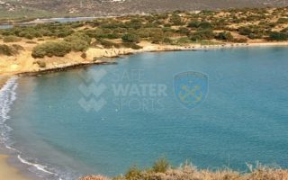
Elouda beach
The nice sandy beach northern to the small port of Elounda is situated at a distance of 11 kilometers far from Aghios Nicolaos at the North, and 70 -77 kilometers eastern to the International Airport of Heraklion, via the New or the Old National road respectively. Protected by the Spinalonga peninsula, the beach is not affected by the winds. Fully organised, the beach offers a wide range of accommodation,... read more
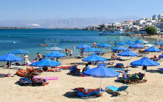
Voulisma beach
Voulisma is the second of the three bays in the beautiful village Istron, about 12km east of Agios Nikolaos and 22km north of Ierapetra. The Voulisma Beach or Golden Sands is located approximately 500m from the village (east). Its length is about 700m and is the largest municipal beach of Kalo Chorio.Voulisma is a very well-organized beach, with rare beauty for a beach located in the Northern part... read more
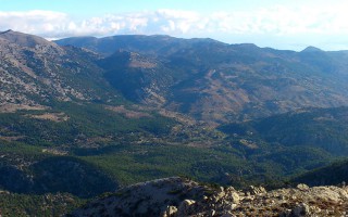
The Dikti Range
THIS RANGE LIES BETWEEN HERAKLION AND LASSITHI. Its highest summit is Spathi (2.148 m) and there are two more peaks at an altitude of more than 2000m. Lassithi Plateau, the largest in Crete, lies at the heart of the range at an altitude of 850 m. It is surrounded by a series of smaller plateaus such as Katharo, Limnakaro, Mari, Lapathos, Omalos, Erganos and Nisimos. There is a mountain shelter at Limnakaro... read more
Lassithi
Any place in Crete is sure to fascinate visitors. The island is reputed for its amazing mosaic of landscapes – each one, however, retaining its own character, its own identity and beauty. The eastern part of Lassithi is considered to be the low-key aspect of Crete, one of peace, quiet, things being done in a relaxed way, hospitality. It is the corner of Crete with the even-tempered mountains,... read more
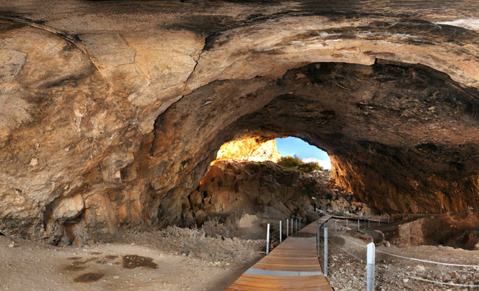
Cave of Pelekita or Cave of the Fig Tree
It lies to the North-Northeast of Kato Zakros. We arrive at the cave either after a one-hour walk from Kato Zakros or from the beach of the same settlement by engine-vessel (20-25 minutes) and after that, we follow a tiresome ascending route (15 minutes walk). The elevation at the entrance attains 105 metres. Stones consist of limestones from the upper Cretaceous and of dolomites from the Triassic... read more
In the area, it is known as Rapas cave. However, it is more widely known as Milatos cave. It lies east of Milatos. From a village, there is a road leading you to the cave area after 2,5 kilometres.
From there, if we follow a path for 15 minutes, we arrive at the entrance of the cave which lies at an elevation of 155 metres. The cave has 8 small and big entrances along 40 metres, arranged on three different horizontal levels.
We use the large central entrance, which is 9 metres in width and 2 metres in height. The rigth entrance (access to the exterior part is difficult) allows for the daylight to illuminate the chamber where the church is situated. Both those entrances lead to the main part of the cave. The others lead to the left smaller part of the cave. In the first part of the main chamber, a church was erected in 1953 dedicated to Saint Thomas.
There, a liturgy (Sunday Mass) is held once a year in commemoration of the Saint, that is on “Thomas Sunday (Second Sunday of Easter). On that day a local celebration of national character takes place in the area.
Near the church, there is an ossuary where some of the sacred relics of victims that died in a battle in 1823 (during the Greek Liberation War against the Turkish Occupation) are kept. After the church, the floor becomes sloping and in the end it becoms horizontal.
In all areas of the cave, there are many small and big pillars arranged in clusters, which constitute an amazing spectacle. Stalagmites are fewer, however very spectacular. Stalactites are scarce. Pillars divide the cave into many chambers.
The cave has been opened up in Cretaceous limestone, at a precession of which lie the entrances. What we can see today are the remains of a bigger undergroung sinkhole that used to expand mainly to the part of the gully. The total length of the cave attains 75 m, the width in the entrance area is 45 metres, which becomes narrower and narrower as we walk further into the cave. The deepest part of the cave is 12 metres lower than the entrance level.
Circulation is easy in many areas. After exploitation of the cave, the walking path will attain 200 metres. The cave has been characterized as a cave of great national interest. It was mapped by El. Platakis on 28th August 1953, while a more detailed mapping was carried out by members of the speleological society led by Anna Petrochilou on 7th December 1969.
Source: www.incrediblecrete.gr
The new aspect of tourism, Sitia Geopark
When the Sitia region became a member of the UNESCO Geopark family, we had no idea just how much positive change this would bring! This new aspect of tourism “Sitia Geopark”, is proving to be a considerable point of interest, especially in the alternative tourism market. The natural environment is no longer an obstacle for tourism development, on the contrary it is a great attraction for visitors. We... read more
Elouda beach
The nice sandy beach northern to the small port of Elounda is situated at a distance of 11 kilometers far from Aghios Nicolaos at the North, and 70 -77 kilometers eastern to the International Airport of Heraklion, via the New or the Old National road respectively. Protected by the Spinalonga peninsula, the beach is not affected by the winds. Fully organised, the beach offers a wide range of accommodation,... read more
Voulisma beach
Voulisma is the second of the three bays in the beautiful village Istron, about 12km east of Agios Nikolaos and 22km north of Ierapetra. The Voulisma Beach or Golden Sands is located approximately 500m from the village (east). Its length is about 700m and is the largest municipal beach of Kalo Chorio.Voulisma is a very well-organized beach, with rare beauty for a beach located in the Northern part... read more
The Dikti Range
THIS RANGE LIES BETWEEN HERAKLION AND LASSITHI. Its highest summit is Spathi (2.148 m) and there are two more peaks at an altitude of more than 2000m. Lassithi Plateau, the largest in Crete, lies at the heart of the range at an altitude of 850 m. It is surrounded by a series of smaller plateaus such as Katharo, Limnakaro, Mari, Lapathos, Omalos, Erganos and Nisimos. There is a mountain shelter at Limnakaro... read more
Lassithi
Any place in Crete is sure to fascinate visitors. The island is reputed for its amazing mosaic of landscapes – each one, however, retaining its own character, its own identity and beauty. The eastern part of Lassithi is considered to be the low-key aspect of Crete, one of peace, quiet, things being done in a relaxed way, hospitality. It is the corner of Crete with the even-tempered mountains,... read more
Cave of Pelekita or Cave of the Fig Tree
It lies to the North-Northeast of Kato Zakros. We arrive at the cave either after a one-hour walk from Kato Zakros or from the beach of the same settlement by engine-vessel (20-25 minutes) and after that, we follow a tiresome ascending route (15 minutes walk). The elevation at the entrance attains 105 metres. Stones consist of limestones from the upper Cretaceous and of dolomites from the Triassic... read more
Frachthi cave is a world famous monument situated at the wild rocky mountain opposite the village Koilada. Excavations brought to light numerous findings among which the oldest human skeleton attesting its continuous occupation for more than 20.000 years. Walk through the beach Lampagianna, climb to the cave and enjoy the view.
 The world famous Frachthi cave is located next to the sea, opposite Koilada village, on a rocky hill covered by shrubs. Visitors can wander in the two chambers of the cave and admire the reflecting sun rays on the small lake situated in the center of the cave. It is west oriented, at an elevation of 12.5m over sea level and in a distance of 50m from the shore. Its total depth reaches 150m. In the past, during the Stone Age the distance to the sea was larger.The cave was first inhabited by the Homo Neanderdhal during the Paleolithic age (40.000 B.C.) and it was re-occupied by homo sapiens (wise human) after 30.000B.C. There are elements illustrating its continuous occupation from 25.000 B.C. to 30.000 B.C. when it was destroyed by a big earthquake.
Originally it was occupied by some hunters that had found refuge in it. During the Middle and Later Neolithic Age more people begun to gather. Sediments that date from the Upper Paleolithical to the Neolithical age have been found in the cave. The excavations conducted in 1967-1976 and 1980-1982 by professors of the Universities of Indiana, brought to light numerous findings that illustrate the continuous inhabitance of the cave during the Stone Age.
 The findings included stone and bone tools, statuettes, ceramic vessels, jewels, shells, and other objects. A rare series of fish bones, mainly of tuna fish was also brought to light. The most significant find, though, is the most ancient human skeleton of a 25years old man, found in a fetal position under a pile of rocks. It is believed that he lived in the cave 10.000-8.000 years ago. More human skeletons were found in the cave providing the average height of humans. Remains of obsidian items found in the cave have been traced to the island of Melos indicating that humans of that period could realize long sea distance travels.
The excavations have been carried out only in the front part of the cave, extending to a surface of 700m. The rest of the cave remains intact keeping its secrets unrevealed. The finds are exhibited in the Archaeological Museum of Nafplio.
The Paleolithical house is a worth visiting and can be accessed by land and by sea. You can also practice climbing on the rocks of the cave, trekking on the Lampagiannas beach and swimming in the crystal blue water.
Source: www.mythicalpeloponnese.gr

Athens and Epidaurus Festival
What is the Athens Festival? A great celebration that has lasted 56 summers, and that has hosted some of the leading lights of theatre, music and dance. From Mitropoulos and Callas to Rostropovich, Pavarotti, Leonidas Kavakos and Dimitris Sgouros. From Theodorakis and Hadjidakis to Savvopoulos, Protopsalti, Dalaras and Marinella. From Rondiris and Koun to Streller, Peter Hall, Noh theatre, Bunraku... read more
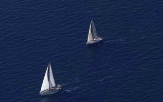
Open Sea Sailing Races
The Nautical Club of New Epidaurus and the Nautical Sports Club of Peace and Friendship organize every June a sailing race in the deep blue sea of New Epidaurus and the Argosaronic Gulf. The Open Sea Sailing Race “Epidaurus” is so vivid, passionate and intense that it will definitely move you. Come to the beautiful port of New Epidaurus and give a very warm applaud to the contestants in a great... read more

Frachthi cave
Frachthi cave is a world famous monument situated at the wild rocky mountain opposite the village Koilada. Excavations brought to light numerous findings among which the oldest human skeleton attesting its continuous occupation for more than 20.000 years. Walk through the beach Lampagianna, climb to the cave and enjoy the view. The world famous Frachthi cave is located next to the sea, opposite... read more
Port of Porto Heli
You can dock your boat at the beautiful and windless port of Porto Heli and enjoy your stay in this cosmopolitan location. The bay is full of yachts and cabin cruisers savoring the warmth of this charming bay. The cosmopolitan town of Porto Heli is one of the most famous summer tourist destinations in Argolida. Its port is located in a closed and protected gulf that protects the boats from wind.... read more
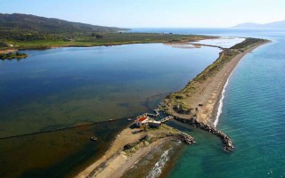
Thermisia Lagoon
Thermisia lagoon is an important habitat of rare migratory birds. It is a serene and unique lagoon surrounded by a breathtaking landscape. Located in the picturesque village of Thermisia, to the east of Ermioni, the lagoon took its name from some hot springs that existed in the area. The Greek traveler Pausanias mentions a temple dedicated to Demeter Thermasia. This magnificent lagoon was used as a salt... read more
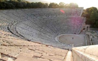
Epidaurus Festival
Every year since 1995, the “Epidaurus Festival” is organized, offering the visitor the opportunity to watch various performances at the imposing ancient theater of Epidaurus. So if you love ancient drama, you must visit this picturesque theater especially on a cool Friday or Saturday night under the moonlight. While it gets dark, you will be able to enjoy the amazing lyrics of the ancient dramatists... read more
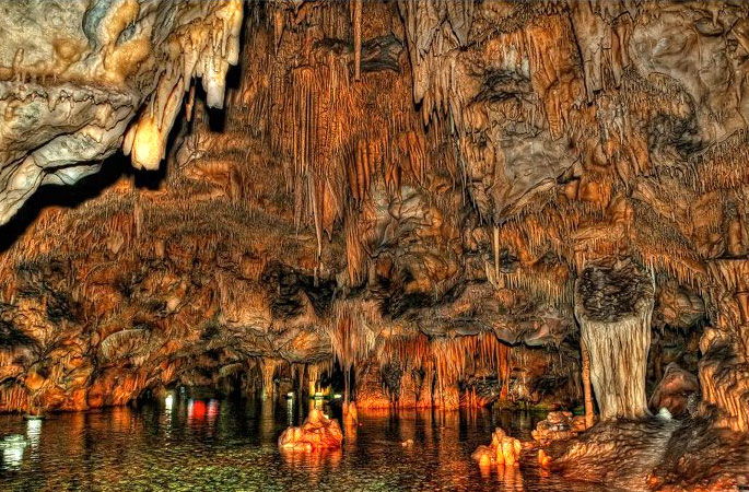
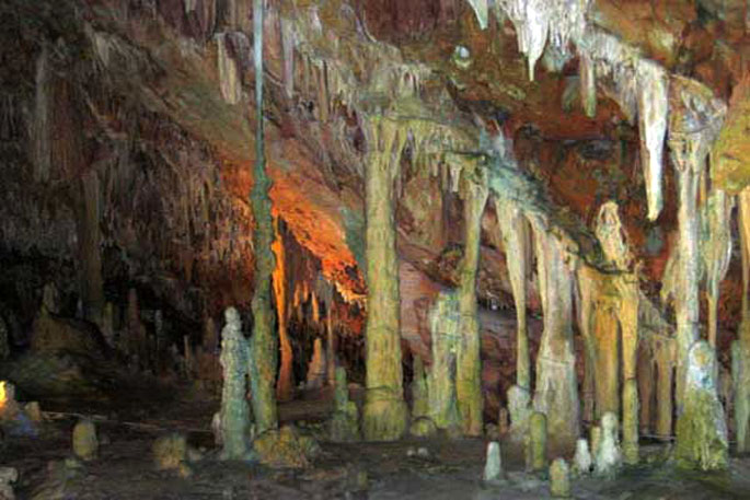
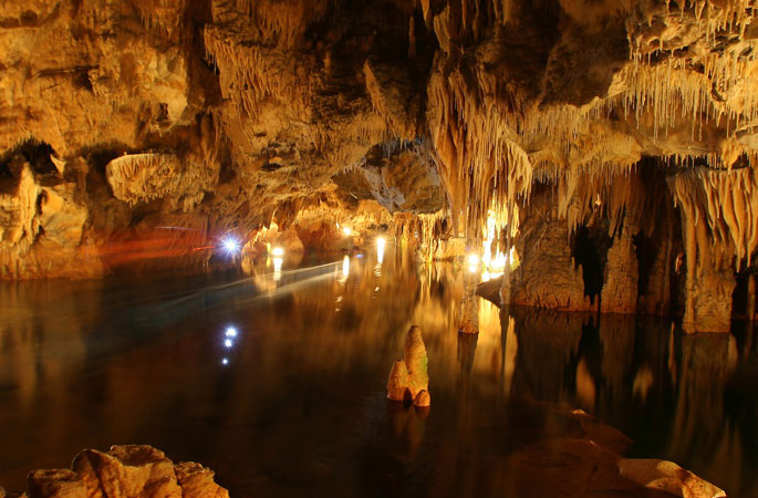
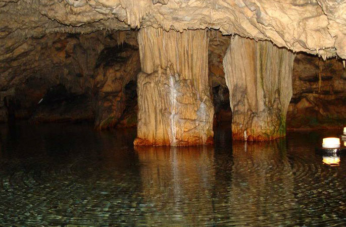
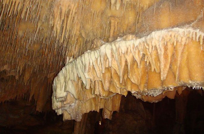
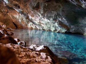
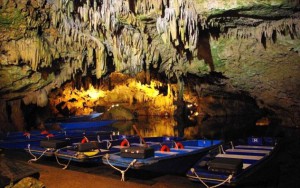 Just south of Aeropolis, at Diros bay, is the Glyfada cave (or Vlychada cave). It offers visitors a spectacular beauty hidden in the depths of the earth. It is a sea cave of exquisite beauty that is considered to be the best from the three most beautiful sea caves in the world. It is a tour sight and is 3.100 meters in length. Visitors can go through dry and wet areas with a plethora of arcades and chambers. Moreover it possesses a sensational, colorful mineral decor of compelling column shaped stalactites and stalagmites. The tour follows a circular route and the wet area, 2.800 meters in length, takes place solely by boat. The cave exploration started in 1949 and today over 10.000 m2 have been explored. The Glyfada Cave at Diros is currently considered the largest and most famous sea cave of the country.
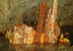 Also known as Vlychada, the Glyfada cave is located on the west coast of the Laconic Peninsula, at Diros bay. The cave consists of a subterranean river that runs through the cave and empties into the sea 23 meters to the right side of the cave’s entrance that is half a meter tall from water level. It is the first cave of this specific area and the best from the three most beautiful sea caves in the world. It possesses a sensational, colorful mineral decor of compelling column shaped gray and white stalactites and stalagmites. It consists of dry and wet areas with a plethora of arcades and chambers, the majority of which is covered in sea water. It is the largest and most well-known cave of the country. It is 3.100 meters in length with only 300 of these being dry. For tour purposes, two new entrances were opened in addition to the existing one. The tour follows a circular route and lasts 45 minutes and the wet areas are solely toured by boat. The cave has a stable temperature of 18⁰ C. The water level fluctuates depending on the outdoor weather conditions, with a maximum water depth of 15.5 meters and a temperature of 12⁰ C. Below the entrance of the cave is Diros bay, with its whitewashed pebbles and crystal clear waters.
The cave was discovered by Petros Arapakis and its exploration started in 1949 by Ioannis and Anna Petrocheilou. Bones of prehistoric oxen, hippopotamus, hyenas and of other animals as well as ceramic utensils of the prehistoric times were found in the cave. Today over 10.000 m2 have been explored. Due to its natural marine entrance, the cave was not use by humans.
Source: www.mythicalpeloponnese.gr

SPARTATHLON HISTORICAL ULTRAMARATHON
SPARTATHLON is a historic ultra-distance foot race that takes place in September of every year in Greece. It is one of the most difficult and satisfying ultra-distance races in the world because of its unique history and background. The Spartathlon revives the footsteps of Pheidippides, an ancient Athenian long distance runner, who in 490 BC, before the battle of Marathon, was sent to Sparta to seek... read more
Mt. Parnonas
Parnonas also known as “Malevos” is the mountain range which divides two large counties of Peloponnese, Arcadia and Laconia. The highest peak of Parnonas is called “Megali Tourla” also known as “Kronio” and has 1936 meters altitude. The mountain ends in Laconia at the Cape Maleas, south of Peloponnese. The natural beauty of the mountain and the traditional villages attract many travelers... read more
E4 European long distance path
The E-path starts at the Pyrenees of Spain, it crosses central Greece, and ends at Larnaka, Cyprus. The southern part of the path begins in Corinth and through Tripoli enters Laconia, crosses Parnon, Sparti and Mystras and climbs the slope of Taygetus and ends in Gytheio. The path follows the route Agios Petros – Karyes – Vresthena – Theologos – Sparti – Mystras – Faneromeni Monastery-... read more
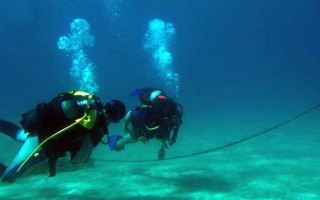
Scuba Diving in Laconia
The crystal clear waters of the Laconian Sea with its rich sea bed offer scuba divers great diving trips. Explore the diverse underwater flora in most of the beaches of the area. In the Laconia region autonomous diving is permitted at the Gulf of Epidaurus Limera that extends from Monemvasia and contains the shores of Myrtoo. In the Laconian gulf free diving is permitted south of cape Psifia, from... read more
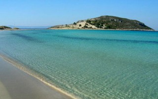
Elafonisos
This small, majestic island on the southern edge of Peloponnese is considered to be one of the most famous touristic destinations for the summer period and its characteristics are the beautiful sandy beaches and the crystal waters. It was named Elafonisos (elafi=deer), after the plethora of red deer in the area. According to Pausanias, there were also a lot of sanctuaries dedicated to Goddess Artemis. At... read more
Cape Tenaro
The ancient people believed that at the end of Mani and of the mainland of Europe were the gates to the Underworld. The visitors can reach on foot the Cape Tenaro, which is filled with remains of antiquities, from the path starting from the little church of Agioi Asomatoi which was built using the stones from the Sanctuary of Poseidon Tenarios. If you walk east, you’ll find sculpted on the rock the Psychomanteion... read more