

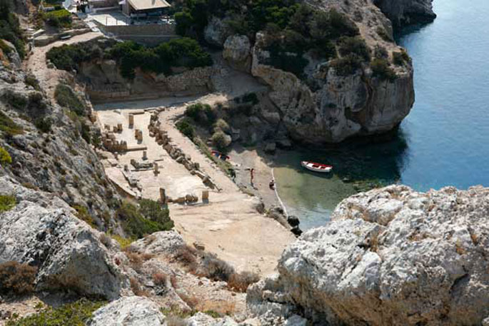
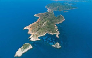
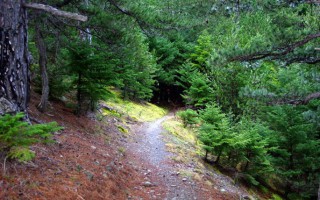
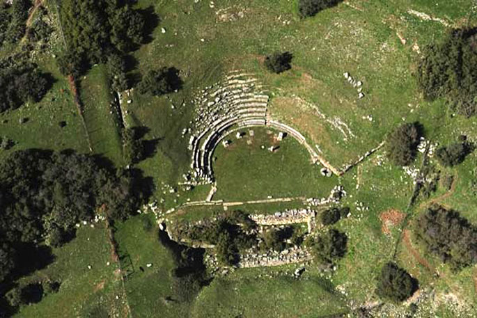
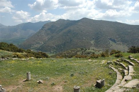
The archaeological site of Heraion is located 15 kilometers to the northwest of Ancient Corinth, at the end of Perachora peninsula. Excavations carried out in the region have brought to light the temple of Hera and significant remains of the early Corinthian civilization, such as an L-shaped stoa, a large cistern, dining rooms and a smaller temple.
 The temple of Hera is the most significant monument of the site. It lies near a small harbor under the lighthouse of Melagavi. The region was an important part of the Corinthian land during the early roman period. The findings in Perachora provide valuable information on Corinthian art from the geometric and archaic period. Excavations (1930-1933) were carried out at the site of Heraion and the temple of Hera Akraia, above the harbor, and Hera Limenia, by the harbor. The investigation extended to Vouliagmeni lake, and it attested the existence of remains that date back to the Neolithic, early Helladic and Mycenaean age. It is believed that a significant town called Heraion existed on the site. The findings in the area indicate that the town Oinoi was located in the area of Schoinos, and that the settlement of Therma was located in the modern town of Loutraki.
Video by fabdrone
Source: www.mythicalpeloponnese.gr
The Semeli Estate, Korinthos
since 1979 “an evolving tradition in winemaking excellence” Founded in 1979, with deep roots in time-honored winemaking traditions and eyes on the future, the Semeli Estate produces wines of exceptional quality offering consumers best value for money. The sunny Mediterranean climate and the extraordinary terroir, combined with the expert craftsmanship of our winemakers and the successful... read more
Centre of History and Science “GRAMMI.org”
The Centre of History and Science "GRAMMI.org" is a new initiative that aims at turning, through its activities, the visit to Corinth to an unforgettable experience. The Centre’s aim is to offer opportunities to visitors to experience, in an innovative, exciting, and interactive way, the importance of Corinth’s history and the scientific and technological achievements connected with it. With... read more
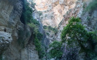
Fonissa Gorge
Fonissa is a stream that forms a deep gorge from Vrysoules village to Loutro, in the municipality of Xylokatsro-Evrostini. In antiquity the stream was the natural borders of ancient Pellene, called Krios (ram). The name “fonissa” (female murderer) highlights how dangerous it is to be in its way when it is full of water. The only way to access the gorge is to follow the road from Kato Loutro village... read more
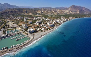
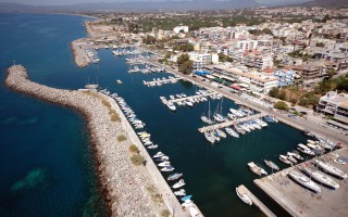
Marina of Xylokastro
There is a small marina at the eastern end Xylokastro. It has a slightly narrow entrance and it consists of two parts, and it is more likely to find a spot to dock at the internal part. It also has a good dock and offers a satisfactory protection, with the city only 5 minutes away, so you can easily get food supplies. Source: www.mythicalpeloponnese.gr [vc_row][vc_column][ivi_nbcaj layout="5"... read more
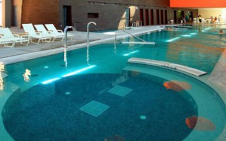
Loutraki Thermal Spa
When you are seeking rejuvenation of the body and the soul, the only choice is the method of hydrotherapy at Loutraki Thermal Spa, in the city of Loutraki. Ancient “Thermes” was a well-known market town at the northern groove of the Corinthian Gulf and it is linked to the mythological “Artmemis Thermia”, who was the protector of the thermal springs. The therapeutic powers of the thermal baths... read more
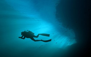
Diving at Corinth
There are many diving schools in Corinthia for those interested in exploring its underwater world. Diving is allowed in the region, except in some specific archaeological sites and sea parks. Fishing with scuba diving equipment is not allowed, including spear guns with oxygen bottles, taking photos or removing antiquities. You can get more information at the local port police stations.Most diving spots... read more
Nemea is a land of legends and traditions. It was the home land of the Nemean Lion, slayed by the legendary Hercules. The Nemean lion was a vicious monster that lived in a cave on mount Triton. Hercules trapped the beast and then killed it with his club. The archaeological site is located on the foothill of the mountains of Arcadia, 333 meters above sea level. The strategic location of Nemea and its climate were the reason that the Panhellenic Games of Nemean were held in the region. During the winter, the region was turned into a swamp, during the summer though it was the ideal place to practice sports. The most significant monuments of Nemea are the temple of Zeus and the Stadium. Since Nemea did not have residents, the management of the games belonged initially to Cleonae and then to Argos.
Source: www.mythicalpeloponnese.gr
The Semeli Estate, Korinthos
since 1979 “an evolving tradition in winemaking excellence” Founded in 1979, with deep roots in time-honored winemaking traditions and eyes on the future, the Semeli Estate produces wines of exceptional quality offering consumers best value for money. The sunny Mediterranean climate and the extraordinary terroir, combined with the expert craftsmanship of our winemakers and the successful... read more
Centre of History and Science “GRAMMI.org”
The Centre of History and Science "GRAMMI.org" is a new initiative that aims at turning, through its activities, the visit to Corinth to an unforgettable experience. The Centre’s aim is to offer opportunities to visitors to experience, in an innovative, exciting, and interactive way, the importance of Corinth’s history and the scientific and technological achievements connected with it. With... read more
Fonissa Gorge
Fonissa is a stream that forms a deep gorge from Vrysoules village to Loutro, in the municipality of Xylokatsro-Evrostini. In antiquity the stream was the natural borders of ancient Pellene, called Krios (ram). The name “fonissa” (female murderer) highlights how dangerous it is to be in its way when it is full of water. The only way to access the gorge is to follow the road from Kato Loutro village... read more
Marina of Xylokastro
There is a small marina at the eastern end Xylokastro. It has a slightly narrow entrance and it consists of two parts, and it is more likely to find a spot to dock at the internal part. It also has a good dock and offers a satisfactory protection, with the city only 5 minutes away, so you can easily get food supplies. Source: www.mythicalpeloponnese.gr [vc_row][vc_column][ivi_nbcaj layout="5"... read more
Loutraki Thermal Spa
When you are seeking rejuvenation of the body and the soul, the only choice is the method of hydrotherapy at Loutraki Thermal Spa, in the city of Loutraki. Ancient “Thermes” was a well-known market town at the northern groove of the Corinthian Gulf and it is linked to the mythological “Artmemis Thermia”, who was the protector of the thermal springs. The therapeutic powers of the thermal baths... read more
Diving at Corinth
There are many diving schools in Corinthia for those interested in exploring its underwater world. Diving is allowed in the region, except in some specific archaeological sites and sea parks. Fishing with scuba diving equipment is not allowed, including spear guns with oxygen bottles, taking photos or removing antiquities. You can get more information at the local port police stations.Most diving spots... read more
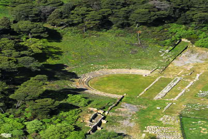
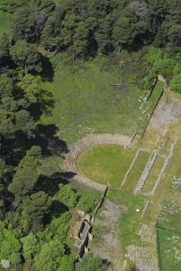
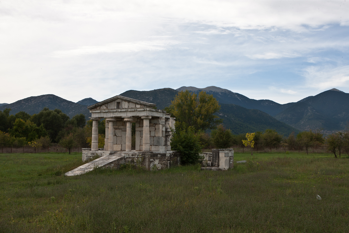
Ancient Sicyon is located on the mound of Vasiliko, a village 4 kilometers to the southeast of Kiato, head of the municipality of Sikyona. In antiquity it was bordered with Corinth to the east, with the Achaean Pellini to the west, and the Arcadian Fliounta and Stymfalos to the south. It was built on a 2300 acres plateau. According to Strabo, Sicyon was located initially by the sea until Demetrios Poliorketes built a new town on the plateau. Demetrios conquered the city and persuaded the Sikyonians to move to the acropolis, leading them to a high triangular plateau. He named the city Demetrias. Most of the public buildings were constructed under the reign of Demetrios and later by Aratos who incorporated the city into the Achaean league. The ancient theater and the roman baths are the most imposing monuments of Ancient Sicyon.
The American School of Classic Studies conducted the first excavations in Ancient Sicyon at the site of the ancient theater, between 1886 and 1898. The excavations were centered around the area of the ancient agora and brought to light a temple, a palaestra, a Bouleuterion, a long Stoa, and a part of the theater’s cavea. All the visible monuments of ancient Sicyon were set according to the Hippodamus Urban Planning System, typical to the Hellenistic town, thus oriented to the four cardinal points.
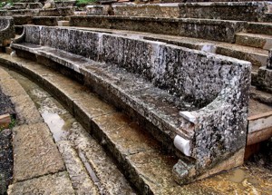
The ancient theater was constructed during the first years of the foundation of the town, around 303 B.C., on the upper mountain plateau of the town. It consisted of the most adequate place to build a theater. Part of the seats was hewn to the rock. The excavations have brought to light the skene, the orchestra and part of the tiers of seats as well as the two vaulted passages leading to the upper diazoma. It is considered as one of the most spectacular theaters of this size, the diameter of its orchestra being 24 meters and the cavea 125 meters. The structure combines the technique of poros stone construction and the chiseling in the natural rock of the hillside. The prohedriai (seats of honor) were located at the first row. The two vaulted passages, leading to the cavea, consisted of the main entrances for the audience. They were 16 meters long and 2.60 meters high and they are preserved in good condition. The orchestra was made of packed earth, while a drainage channel covered by stone slabs runs vertically through the orchestra and ends in the rear of the Skene. The parodoi provided gated entrances similar to those in Epidaurus. The planning and the construction of the theater date back to the late 4th century or early 3rd B.C. The site was used for theatrical performances and political meetings by the citizens of Sicyon.
To the northwest of the theater lies the stadium. Its track is 207 meters long. Part of the retaining wall of sling can be visible though it has not been excavated yet. The stone roman baths, to the north of the agora, are preserved in good condition and they host, at the present, the Archaeological Museum. The visible parts of the ancient construction attest the existence of a large edifice structured around a central courtyard that dated to the 1st or 2nd century A.D.
The foundations of the Bouleuterion of Hellenistic Sicyon have also been discovered. It consisted of a spacious square edifice (40.5 × 41.15 meters) with four internal rows of four columns and a stoa along the façade, on the north side. Both the Bouleuterion and the stoa date to the Hellenistic Period and they were restored in later periods.
The Gymnasium was a large square building. The palaestra was built to the west of the agora, in two levels because of the nature of the ground. It consisted of the basic part of the Gymnasium. The lower lever, 72 × 36 meters, is the most ancient and it dates back to the early 3rd century B.C. The east part, considered the main Gymnasium, was constructed around 280 B.C. by the father of Aratus, Kleinias. The upper part was added later during the roman period.
Another monument worth visiting is the ruins of the archaic temple, near the Agora precinct, built in the 7th century. The temple was dedicated to Artemis or Apollo. It is an east oriented peripteral temple (38.07×11.55 meters) built of soft stone. The first construction phase dates back to the archaic period (6th century B.C.). The temple is of the only archaic edifice visible today. The ancient Agora extends to the east of the theater. It was the center of the excavations conducted by the Archaeological Society. The southwest side of the Agora was bordered by the large stoa, the Bouleuterion, the palaestra and a second stoa to the south of the palaestra The temple was located in the Agora.
Source: www.mythicalpeloponnese.gr
The Semeli Estate, Korinthos
since 1979 “an evolving tradition in winemaking excellence” Founded in 1979, with deep roots in time-honored winemaking traditions and eyes on the future, the Semeli Estate produces wines of exceptional quality offering consumers best value for money. The sunny Mediterranean climate and the extraordinary terroir, combined with the expert craftsmanship of our winemakers and the successful... read more
Centre of History and Science “GRAMMI.org”
The Centre of History and Science "GRAMMI.org" is a new initiative that aims at turning, through its activities, the visit to Corinth to an unforgettable experience. The Centre’s aim is to offer opportunities to visitors to experience, in an innovative, exciting, and interactive way, the importance of Corinth’s history and the scientific and technological achievements connected with it. With... read more
Fonissa Gorge
Fonissa is a stream that forms a deep gorge from Vrysoules village to Loutro, in the municipality of Xylokatsro-Evrostini. In antiquity the stream was the natural borders of ancient Pellene, called Krios (ram). The name “fonissa” (female murderer) highlights how dangerous it is to be in its way when it is full of water. The only way to access the gorge is to follow the road from Kato Loutro village... read more
Marina of Xylokastro
There is a small marina at the eastern end Xylokastro. It has a slightly narrow entrance and it consists of two parts, and it is more likely to find a spot to dock at the internal part. It also has a good dock and offers a satisfactory protection, with the city only 5 minutes away, so you can easily get food supplies. Source: www.mythicalpeloponnese.gr [vc_row][vc_column][ivi_nbcaj layout="5"... read more
Loutraki Thermal Spa
When you are seeking rejuvenation of the body and the soul, the only choice is the method of hydrotherapy at Loutraki Thermal Spa, in the city of Loutraki. Ancient “Thermes” was a well-known market town at the northern groove of the Corinthian Gulf and it is linked to the mythological “Artmemis Thermia”, who was the protector of the thermal springs. The therapeutic powers of the thermal baths... read more
Diving at Corinth
There are many diving schools in Corinthia for those interested in exploring its underwater world. Diving is allowed in the region, except in some specific archaeological sites and sea parks. Fishing with scuba diving equipment is not allowed, including spear guns with oxygen bottles, taking photos or removing antiquities. You can get more information at the local port police stations.Most diving spots... read more
The first settlers of Pheneos were the Pelasgeans. Later, in 1900 B.C. it was inhabited by the Arcadians. They were succeeded by the Achaeans, in 1500 B.C., who created the Mycenaean center of Pheneos and participated to the Trojan War with sixty soldiers under the rule of Agathenoras, king of the Arcadians.
 The acropolis of ancient Pheneos is located near the modern village of Ancient Pheneos, or Kalyvia, to the northwest of the valley of Pheneos. The Ephor of Argolid, E. Deilaki, carried out excavations during the period 1958-1961 and brought to light Asclepeion. It measured 10 × 6.10 meters. Two enormous marble sandaled feet were found on a rectangular pedestal. A female marble head was found behind the pedestal. The two statues that date to 150 B.C. depict Asclepius and Hygeia. All of the findings are exposed in the local archaeological museum. The most impressive is the marble head of Hygeia.
Source: www.mythicalpeloponnese.gr
The Semeli Estate, Korinthos
since 1979 “an evolving tradition in winemaking excellence” Founded in 1979, with deep roots in time-honored winemaking traditions and eyes on the future, the Semeli Estate produces wines of exceptional quality offering consumers best value for money. The sunny Mediterranean climate and the extraordinary terroir, combined with the expert craftsmanship of our winemakers and the successful... read more
Centre of History and Science “GRAMMI.org”
The Centre of History and Science "GRAMMI.org" is a new initiative that aims at turning, through its activities, the visit to Corinth to an unforgettable experience. The Centre’s aim is to offer opportunities to visitors to experience, in an innovative, exciting, and interactive way, the importance of Corinth’s history and the scientific and technological achievements connected with it. With... read more
Fonissa Gorge
Fonissa is a stream that forms a deep gorge from Vrysoules village to Loutro, in the municipality of Xylokatsro-Evrostini. In antiquity the stream was the natural borders of ancient Pellene, called Krios (ram). The name “fonissa” (female murderer) highlights how dangerous it is to be in its way when it is full of water. The only way to access the gorge is to follow the road from Kato Loutro village... read more
Marina of Xylokastro
There is a small marina at the eastern end Xylokastro. It has a slightly narrow entrance and it consists of two parts, and it is more likely to find a spot to dock at the internal part. It also has a good dock and offers a satisfactory protection, with the city only 5 minutes away, so you can easily get food supplies. Source: www.mythicalpeloponnese.gr [vc_row][vc_column][ivi_nbcaj layout="5"... read more
Loutraki Thermal Spa
When you are seeking rejuvenation of the body and the soul, the only choice is the method of hydrotherapy at Loutraki Thermal Spa, in the city of Loutraki. Ancient “Thermes” was a well-known market town at the northern groove of the Corinthian Gulf and it is linked to the mythological “Artmemis Thermia”, who was the protector of the thermal springs. The therapeutic powers of the thermal baths... read more
Diving at Corinth
There are many diving schools in Corinthia for those interested in exploring its underwater world. Diving is allowed in the region, except in some specific archaeological sites and sea parks. Fishing with scuba diving equipment is not allowed, including spear guns with oxygen bottles, taking photos or removing antiquities. You can get more information at the local port police stations.Most diving spots... read more
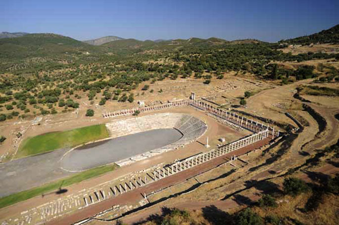
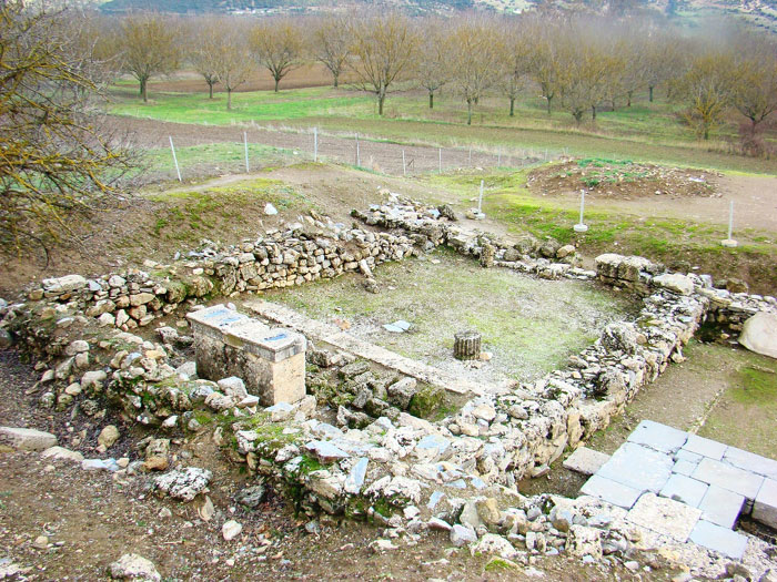
Ancient Messene is situated in the western foothills of mountain Ithomi, near the village called today Mavromati. A large part of the city has come to light, which reveals its great expanse and also its significance during ancient times. Ancient Messene was built in 369 B.C. by the general Epaminondas from Thebes after the battle at Lefktra, when he defeated the Spartans, invaded Laconia and released the Messenians from the Spartan rule.
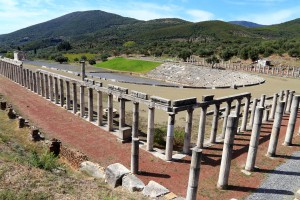 The traveller Pausanias visited the city between 155 and 160 B.C. and recorded significant information regarding its form and all public and holy buildings. First of all the stone wall that enclosed it, which was approximately nine kilometres long and protected the city from all directions, apart from the northeast, where Ithomi stood as a natural fort. Apart from part of this wall, the archaeological excavations also brought to light: the Theatre, which mainly hosted political assemblies, the Arsinoe Fountain, a large and impressive construction between the Theatre and the Agora, the western part of the Agora, the sanctuary of Zeus Soter, the sanctuary of Demeter and the Dioscouri, the Asclepium, which seemed to play an important role in the public life of the city, the sanctuary of a hero, probably Aristomenes, the Ecclesiasterion, the Stadium, the Gymnasium, as well as the Arcadian Gate, great in size, which is mentioned many times by the travellers as one of the archaeological site’s most impressive constructions.
To the south west of Peloponnesus, next to the modern-day village of Mavromati, in ancient times lay the city of Messene, one of the most important ancient cities of the region, with a significant historical presence. The city was founded in 369 BC by the Theban general Epameinondas and his allies from Argos, with the purpose of excluding the Spartans from the Messenian region.
Video by fabdrone
Legend has it that the specific location for the establishment of the new city was selected after the location of the will of Aristomenes, a Messenian hero, was miraculously revealed through the intervention of priests and oracles. According to Pausanias, in order to populate the new city, Messenian immigrants in Italy, Sicily, Evesperides in Libya, as well as various other cities where they had settled, were called back. Most of them replied positively to the invitation to settle the new city, and together with the freed slaves and the perioeci (the free but non-citizens of Sparta), they comprised the first population of Messene. The city got its name from the legendary, pre-Doric queen of the land, who was the daughter of King Triopas of Argos and wife of Polycaon of Laconia. According to Pausanias, Messene was deified circa 10th century BC and was gradually declared one of the main deities of the city.
Systematic excavations started in 1895 by Themistocles Sofoulis and were continued in 1909 and 1925 by Georgios Oikonomou. Anastasios Orlandos later researched the area until 1974, while from 1986 the excavations are directed by Petros Themelis. Throughout these years, many public and sacred buildings were brought to light, as seen and described by Pausanias, who visited the city in years 155-160 AD, during the reign of Emperor Antoninus Pius.
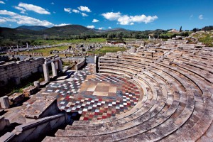 Ancient Messene was surrounded by a nine and a half kilometre wall, its largest part still standing to this day. It had two gates, the Arcadian Gate (or Gate of Megalopolis) and the Laconian Gate. This last gate was destroyed in the 18th century, but the Arcadian Gate is still preserved in fairly good condition, and in fact was the city’s landmark for the first travellers, who liked to depict it in their engravings. It is an enormous and imposing circular gate, with two entrances, one interior and one exterior.More discoveries were made in ancient Messene, such as the theatre, the agora, the temples of Demeter, the Dioskouroi, Zeus Sotiros, as well as of Isis and Serapis; the temple of a hero, the imposing Spring of Arsinoe, a large Doric temple, the Asclepeion, which was the most magnificent public building; the ecclesiasterion, which is a type of small theatre, the stadium, the gymnasium, and from later times a basilica of the early Byzantine era.
The city’s layout followed the hippodamian system, where all buildings have the same orientation and space is divided along horizontal and vertical axes. Hippodamus of Miletus was the father of this system. He was an architect, mathematician, urban planner and astronomer who lived circa 5th century BC, and he based his system on the three principles of democracy: isonomy (equality before the law), isopolity (equal civic rights) and isomoiria (equal share in land ownership).
The city fell victim to a raid by the Goths in 395 BC, led by Alarichus, and after that it gradually became deserted. It is however still one of the best preserved cities of the ancient world and one of the most interesting archaeological destinations.
Source: www.mythicalpeloponnese.gr

Kalamata Gastronomic Destination
Professionals in the field of gastronomy in its broadest sense – the agricultural sector, processing, hospitality, restaurants – have joined forces and created a society called the Gastronomic Community of Kalamata. Their goal is to enlist the best food-related businesses in the region, to set up a parallel structured link between Tourism and the Gastronomic Culture of Messinia, and to promote... read more
Kalamata Marina
The marina offers a full range of technical services covering a wide range of maintenance and repair works. Kalamata marina is situated in Peloponnesus in Kalamata city on the west of Kalamata harbour in the Messinian Gulf, and is considered by many to be the ideal location to take refuge and rest as it is the passage from the Mediterranean and the Ionian Sea to the Aegean Sea. Kalamata is a modern... read more
Sapientza and the Perennial Broadleaf Forest
Sapientza is an islet of the Messinian Oinousses cluster and is the second biggest after Schiza. It’s an island with lush vegetation, a rare flora and a total area of 9 square kilometres. In 1986, Sapientza was declared as a “listed natural monument” and it was included in the European Network Natura 2000, together with the neighboring Schiza and the area around cape Akritas.Sapientza in Italian... read more
Gialova Lagoon
Gialova lagoon is located in Messinia and is one of the most important wetlands not only in Greece, but also in Europe. It probably dates to prehistoric times and owes its creation both to tectonic activity and to a rise in sea level, phenomena which created this ecological zone of unique importance.The Gialova lagoon is the first station in the Balkans that the migratory birds from Africa come across;... read more
The Gorge of Neda
Neda is the only “female” river in Greece. It stems from the foot of Mount Lykaion and flows into the Ionian Sea, more specifically into the Kyparissiakos Gulf. Neda is approximately 32 kilometres long and passes through a stunning fairytale-like landscape.The Valley of Neda was of particular importance to the ancient Greeks and was often mentioned in various myths, while it is surrounded by archaeological... read more
Vassiliki Forest
The forest of Vassiliki is located at the southern part of the Taygetus mountain range, 8 km south of its summit, and has an expanse of approximately 11,000 stremmata. It is a relatively secluded forest, surrounded by summits. You can reach it from Eksochori and there is a road in the forest you can follow for 21 km. Here you will mostly come across fir trees and black pines. During the Italian... read more
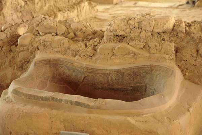
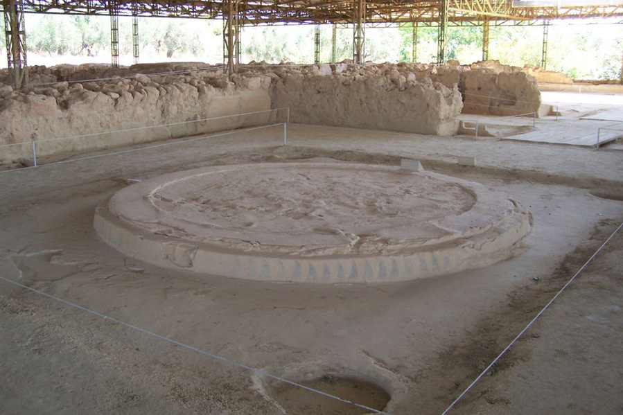
Fourteen kilometres from Pylos, on the hill of Epano Eglianos, in the previous century came to light the palace of Nestor, the famous king of Pylos. It is the best-preserved Mycenaean palace in the whole of Greece.
The palace complex comprises four structures, which include a series of apartments. Impressive is the fact that the interior was adorned by colour murals, and also the fact that the palace was never enclosed within a protective wall, since its location was enough to grant it ample protection. The palace seems to have been completely destroyed by a fire during the 12th century B.C., which, however, managed to preserve a plethora of clay tablets that contain significant information regarding the financial, social and religious life during Mycenaean times.Those who visit the area can also see the tholos tomb attributed to Nestor and his successor, Thrasymedes, which was discovered near the palace, as well as all the archaeological findings from the excavations, exhibited in the Museum of Chora.
The Mycenaean civilization flourished during the period between 1700—1001 BC in various parts of the Helladic region. Its archaeological traces were first discovered in the region of Mycenae, from where it takes its name. Amongst the most important findings this magnificent civilization has bequeathed to us are the tholos tombs and the grandiose palaces.
 The palace of the mythical king of Pylos, Nestor, belongs to this category of Mycenaean palaces – in fact it is the best preserved of all those discovered in Greece. It is situated four kilometres south of the village of Chora, on the hill of Epano Englianos, and 14 kilometres from Pylos. The palace was built in the 13th century BC by King Nestor, son of Neleus, who is mentioned several times by Homer and holds an important role in his epic poems. Nestor led Pylos to the Trojan War with 90 ships and is described by Homer as a wise elder, his opinion always respected by the Achaeans.
Heinrich Schliemann was the first to start looking for this mythical palace in 1888, having certain suspicions regarding its location, but he was not successful. It was not until 1939, after intensive excavations, when Konstantinos Kourouniotis, together with Carl Bergen, brought to light the first findings from the palace. World War II put a halt to excavations for some time, which were started again in 1952. Even though the largest part of the palace has been uncovered, research continues until the present day with the participation of the University of Cincinnati, USA.
This complex of palaces consists of four main buildings, which, in turn, have a large number of rooms – 105 according to calculations. The most important room is, of course, the so-called “throne room”, with its central round hearth. Additionally, the ruins of a central two-storey building and two auxiliary spaces were uncovered, while tholos tombs were excavated in the area surrounding the palace, one of them attributed to Nestor and his successor, Thrasymedes.
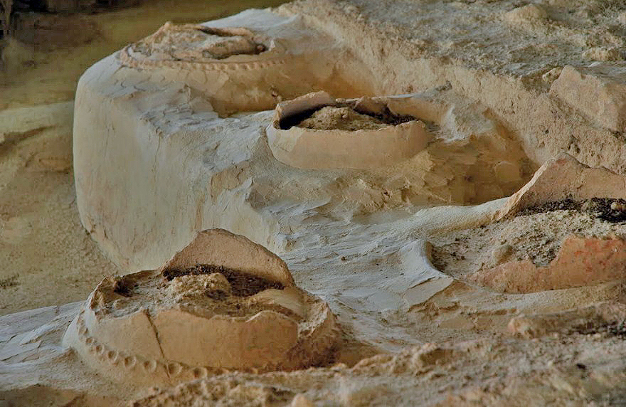 The numerous findings brought to light by the excavations include approximately 1,250 clay tablets written in Linear B. The tablets were deciphered in 1952 by Michael Ventris, an architect, and John Chadwick, a linguist. It is thanks to them that we are now in a position of knowing important information about the daily life, as well as the financial and commercial activities of prehistoric Pylos in general, and about the palace in particular. The remarkable thing about these tablets is the fact that they would not have been preserved to this day if not for a fire that levelled the palace in the 12th century. The palace itself never recovered from this disaster, but the fire had the effect of “baking” the clay tablets, making them more durable.
The numerous archaeological findings from the site of the Palace of Nestor are today kept at the Archaeological Museum of Chora.
Source: www.mythicalpeloponnese.gr
Kalamata Gastronomic Destination
Professionals in the field of gastronomy in its broadest sense – the agricultural sector, processing, hospitality, restaurants – have joined forces and created a society called the Gastronomic Community of Kalamata. Their goal is to enlist the best food-related businesses in the region, to set up a parallel structured link between Tourism and the Gastronomic Culture of Messinia, and to promote... read more
Kalamata Marina
The marina offers a full range of technical services covering a wide range of maintenance and repair works. Kalamata marina is situated in Peloponnesus in Kalamata city on the west of Kalamata harbour in the Messinian Gulf, and is considered by many to be the ideal location to take refuge and rest as it is the passage from the Mediterranean and the Ionian Sea to the Aegean Sea. Kalamata is a modern... read more
Sapientza and the Perennial Broadleaf Forest
Sapientza is an islet of the Messinian Oinousses cluster and is the second biggest after Schiza. It’s an island with lush vegetation, a rare flora and a total area of 9 square kilometres. In 1986, Sapientza was declared as a “listed natural monument” and it was included in the European Network Natura 2000, together with the neighboring Schiza and the area around cape Akritas.Sapientza in Italian... read more
Gialova Lagoon
Gialova lagoon is located in Messinia and is one of the most important wetlands not only in Greece, but also in Europe. It probably dates to prehistoric times and owes its creation both to tectonic activity and to a rise in sea level, phenomena which created this ecological zone of unique importance.The Gialova lagoon is the first station in the Balkans that the migratory birds from Africa come across;... read more
The Gorge of Neda
Neda is the only “female” river in Greece. It stems from the foot of Mount Lykaion and flows into the Ionian Sea, more specifically into the Kyparissiakos Gulf. Neda is approximately 32 kilometres long and passes through a stunning fairytale-like landscape.The Valley of Neda was of particular importance to the ancient Greeks and was often mentioned in various myths, while it is surrounded by archaeological... read more
Vassiliki Forest
The forest of Vassiliki is located at the southern part of the Taygetus mountain range, 8 km south of its summit, and has an expanse of approximately 11,000 stremmata. It is a relatively secluded forest, surrounded by summits. You can reach it from Eksochori and there is a road in the forest you can follow for 21 km. Here you will mostly come across fir trees and black pines. During the Italian... read more
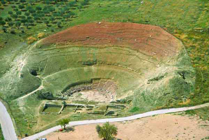
Orchomenus was a city in ancient Arcadia, its ruins today situated approximately 30 kilometres from Tripoli, a small distance outside the village of Levidi.
Orchomenus was one of the oldest cities in the region, with evidence of prehistoric inhabitation. It had a large population, as well as a significant presence in the events of the time, and there are testimonies that it was a particularly rich city, since it struck its own coin. Orchomenus was one of the three “large powers” of eastern Arcadia, together with Tegea and Mantineia, with both of which, in fact, it was in constant opposition. Its greatest peak was during the Archaic period, circa the 7th and 6th centuries BC. The city was abandoned during the Roman and Byzantine years, and its inhabitants relocated to the surrounding regions.
The main city is situated on a hill dominating the valley of Levidi and Kandila, an impressive – as well as strategic – position, as it allowed control of the region over a fairly large distance. This ancient city has been excavated and is now open to visitors. The first systematic excavations took place in 1913 by G. Blum and A. Plassart, while during the years 1973-1976 new excavations were carried out by the Supervisory Service of the Prefecture of Arcadia, the 5th Ephorate of Prehistoric and Classical Antiquities, under the direction of its former Head, G. Stainhower. Further works were carried out in 1980 under the direction of former Head, Th. Spyropoulos.
 Among the monuments brought to light are a bridge dating to the Archaic period, a prehistoric tomb, the ancient agora, the bouleuterion, a temple to Artemis Mesopolitis, its walls, and most importantly the ancient theatre, one of the largest theatres of the ancient times, with a capacity for 4,000 people, built during the Hellenistic period, in the 3rd century BC. This theatre, built at an altitude of 800 metres, offered a unique view. It was used both for plays and for games in honour of the god Dionysus. An interesting fact is that, as this theatre was built on a steep slope, it had a system for draining rainwater, which consisted of separate stone drainage pipes.
Source: www.mythicalpeloponnese.gr
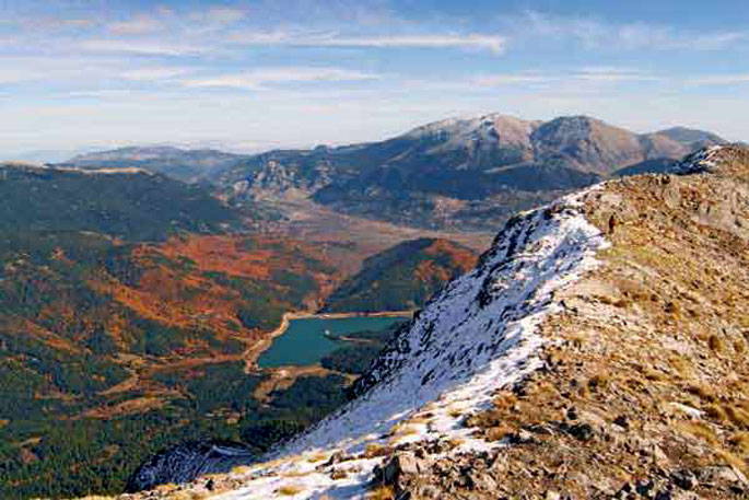
Mt. Parnonas
Parnonas also known as “Malevos” is the mountain range which divides two large counties of Peloponnese, Arcadia and Laconia. The highest peak of Parnonas is called “Megali Tourla” also known as “Kronio” and has 1936 meters altitude. The mountain ends in Laconia at the Cape Maleas, south of Peloponnese. The natural beauty of the mountain and the traditional villages attract many travelers... read more
Alfeios
Peloponnese’s longest river (111km long) has its source in Arcadia and its mouth in the Prefecture of Elis. According to mythology, Apheus was one of the river-gods of antiquity, worshiped mainly in the regions of Arcadia, Elis and Messinia. Son of Oceanus and Tethys, he killed his brother Cercaphus and haunted by the Erinyes, he leapt into the river which was later named after him. Source: www.mythicalpeloponnese.gr [vc_row][vc_column][ivi_nbcaj... read more
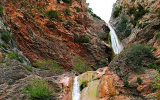
The Gorge of Lepida
The gorge of Lepida is one of the numerous, impressive natural formations of Mount Parnon, which stands between the prefectures of Arcadia and Laconia. Its length is 500 metres and it is relatively flat. Two hours are required to cross it, during which visitors will have the opportunity to enjoy the unique natural beauty of the landscape, which is filled with rich flora and fauna and boasts two gorgeous... read more
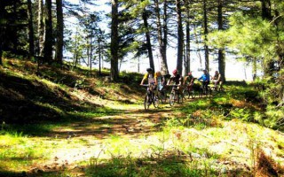
Mountain biking
A great way to discover a new place is actually on two wheels. Arcadia, with its stunning nature, does offer visitors this unique opportunity. The changes in the landscape, the lush vegetation, the dense forests and the hidden traditional settlements are only few of the natural attractions a visitor can enjoy with just a bike and the desire for exploration. Around the city of Tripolis, as well as in the Arcadian... read more
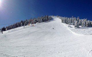
The Ski Center in Mainalo
The Mainalo ski center is situated in the location Ostrakina of the homonymous mountain, approximately 30 kilometres from Tripolis and 162 kilometres from Athens. The roads and consequently the access to the ski centre are easy, making it a very popular destination. It isn’t one of the biggest ski centres; however, it is ideal for families with children, since the mountain is not steep and is perfect... read more
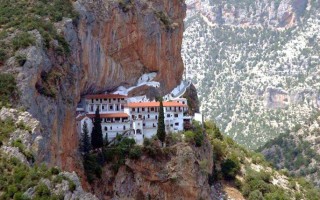
The Monastery of Eloni and the Gorge of Leonidio
The Monastery of Eloni is a pretty old convent in the prefecture of Arcadia, built in the steep slope of Mount Parnon, at an altitude of 650 metres and about 17 kilometres from the town of Leonidio. Due to its exceptional natural beauty, the area around the monastery has been declared as a protected zone and it’s included in the European Network Natura 2000 under the code GR2520005. It has a long... read more
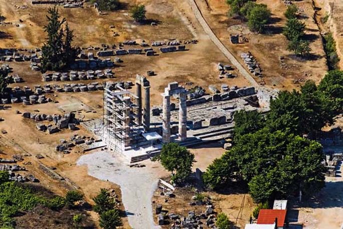
 Three kilometres outside modern-day Megalopoli, in close proximity to the road leading from Megalopoli to Karytaina, lies the archaeological site of Megali Polis, one of the most magnificent cities of ancient Arcadia which, despite this, did not manage to survive for more than two centuries. The archaeological site contains ruins of the ancient agora, the Thersileion parliament hall on the north side, with a capacity of approximately 16,000, as well as the largest and oldest theatre of Ancient Greece, situated across from the agora and connected to it by a bridge.
 The theatre was constructed by Polycleitus of Argos, circa 370 BC, and had a capacity of around 20,000 spectators and perfect acoustics. The reason its proportions were so large was that, in addition to theatre, it also hosted meetings of a political nature between the 40 Arcadian cities that comprised Megalopolis, which could be attended by any interested citizen. A wooden stage with wheels was used for plays, which was kept at the scenotheque (the stage store) and would be pulled out to the theatre whenever needed. The theatre’s peak is placed in the 3rd century BC, and coincides with the peak period of Megali Polis. The theatre first started to come to light in the late 19th century. The British Institute started excavations in the region in 1890-1891, which revealed the proscenium, orchestra, part of the proedria, the analemma walls of the parodoi, the foundations of the scenotheque and the lower stone seats. Research is still underway at the Thersileion parliament hall site, and new results are expected. The ancient theatre of Megalopolis is part of a European programme financed by UNESCO. The goal is to carry out the necessary restoration works that will further highlight the importance of this ancient monument.
Source: www.mythicalpeloponnese.gr
Mt. Parnonas
Parnonas also known as “Malevos” is the mountain range which divides two large counties of Peloponnese, Arcadia and Laconia. The highest peak of Parnonas is called “Megali Tourla” also known as “Kronio” and has 1936 meters altitude. The mountain ends in Laconia at the Cape Maleas, south of Peloponnese. The natural beauty of the mountain and the traditional villages attract many travelers... read more
Alfeios
Peloponnese’s longest river (111km long) has its source in Arcadia and its mouth in the Prefecture of Elis. According to mythology, Apheus was one of the river-gods of antiquity, worshiped mainly in the regions of Arcadia, Elis and Messinia. Son of Oceanus and Tethys, he killed his brother Cercaphus and haunted by the Erinyes, he leapt into the river which was later named after him. Source: www.mythicalpeloponnese.gr [vc_row][vc_column][ivi_nbcaj... read more
The Gorge of Lepida
The gorge of Lepida is one of the numerous, impressive natural formations of Mount Parnon, which stands between the prefectures of Arcadia and Laconia. Its length is 500 metres and it is relatively flat. Two hours are required to cross it, during which visitors will have the opportunity to enjoy the unique natural beauty of the landscape, which is filled with rich flora and fauna and boasts two gorgeous... read more
Mountain biking
A great way to discover a new place is actually on two wheels. Arcadia, with its stunning nature, does offer visitors this unique opportunity. The changes in the landscape, the lush vegetation, the dense forests and the hidden traditional settlements are only few of the natural attractions a visitor can enjoy with just a bike and the desire for exploration. Around the city of Tripolis, as well as in the Arcadian... read more
The Ski Center in Mainalo
The Mainalo ski center is situated in the location Ostrakina of the homonymous mountain, approximately 30 kilometres from Tripolis and 162 kilometres from Athens. The roads and consequently the access to the ski centre are easy, making it a very popular destination. It isn’t one of the biggest ski centres; however, it is ideal for families with children, since the mountain is not steep and is perfect... read more
The Monastery of Eloni and the Gorge of Leonidio
The Monastery of Eloni is a pretty old convent in the prefecture of Arcadia, built in the steep slope of Mount Parnon, at an altitude of 650 metres and about 17 kilometres from the town of Leonidio. Due to its exceptional natural beauty, the area around the monastery has been declared as a protected zone and it’s included in the European Network Natura 2000 under the code GR2520005. It has a long... read more
Mantineia was one of the largest and most significant cities in antiquity and it became an important centre of historical developments not only in the area of Arcadia, where it belonged, but in the whole of Greece. The ancient city is located 14 kilometres from Tripoli, in the area called Paleopoli. The first excavations began at the end of the 19th century and around 1960 other parts of the city came to light.
 The most important monuments that the visitor to the archaeological site of Mantineia can see are the ancient theatre, the Bouleftirion, parts of the ancient Agora, Roman baths and a temple which was dedicated to Artemis Mesopolitis. Across the archaeological site one can also visit the Christian church of Aghia Fotini, a combination of Byzantine and Greek architecture, the aesthetics of which are a source of conflicting opinions.
Regarding the preserved monuments, our best source of information is the traveller Pausanias, who visited the city around 170 A.D. and refers to them in detail. The archaeological site begins from the hill Gortsouli, where the acropolis of ancient Mantineia was located. From the top of this hill the visitor has a great, panoramic view of the whole valley of Mantineia, with the remains of the ancient city.
Video by fabdrone
 The ancient city of Mantineia is situated approximately 14 kilometres north of Tripoli, at Palaiopoli, one of the largest, most important and best preserved cities of the ancient world. Pausanias reports that Mantineas was the city’s legendary settler, grandson of Pelasgus, primogenitor of the Arcadians. The city is also mentioned by Homer, who calls it Mantinei eratinei, meaning “beloved land”. As this ancient reference reveals, Mantineia was a city already at its peak during the Archaic period, playing an important role in the events, not only of Arcadia, but of the entire ancient world.
The first excavations in the region started between 1887 and 1889 by the French Archaeological School, led by Gustave Fougères, and they brought to light the Ancient Agora. Later excavations were undertaken in 1960 by the Greek Archaeological Service and revealed even more relics of this glorious city. The testimony of traveller Pausanias, who visited the city around 170 AD, helped in the identification of these discoveries as the main temples and public buildings of the city.
Mantineia had an impressive fortification wall, the agora, a theatre from the early Hellenistic times, a bath complex dating to the Roman period, the bouleuterion, a temple of Artemis Mesopolitis, as well as two temples which were possibly related to the worship of Zeus and Hera. Residences and tombs have also been located, but they are still well protected underground. Close to the archaeological site lies the Christian church of Saint Foteini, which combines Byzantine and Greek architecture. North of the ancient city, at a distance of approximately one kilometre, is the hill of Gortsouli, which has been identified as the administrative centre of the ancient city, known in ancient texts as Ptolis. A temple was discovered on this hill, which marks the beginning of the archaeological site.
Mantineia had significant presence and power in ancient times, also owing to its strategic position. Its perpetual competitor was Sparta; both cities claiming control of the wider region. This competition resulted in the city’s first destruction in 385 BC, by Agesipolis, King of Sparta. The residents then abandoned their destroyed homeland and scattered into the surrounding areas until 370 BC, when the city was re-established by the Theban general, Epameinondas. In 223 BC the city was destroyed once again by the Macedonian king Antigonos C who, together with his Achaean allies, conquered and looted the city, and massacred its population. The city was again rebuilt in 221 BC under a different name: it was named Antigonia, from the Macedonian king. It kept this name for some centuries, before the Emperor Hadrian gave it back its original name.
Source: www.mythicalpeloponnese.gr
Mt. Parnonas
Parnonas also known as “Malevos” is the mountain range which divides two large counties of Peloponnese, Arcadia and Laconia. The highest peak of Parnonas is called “Megali Tourla” also known as “Kronio” and has 1936 meters altitude. The mountain ends in Laconia at the Cape Maleas, south of Peloponnese. The natural beauty of the mountain and the traditional villages attract many travelers... read more
Alfeios
Peloponnese’s longest river (111km long) has its source in Arcadia and its mouth in the Prefecture of Elis. According to mythology, Apheus was one of the river-gods of antiquity, worshiped mainly in the regions of Arcadia, Elis and Messinia. Son of Oceanus and Tethys, he killed his brother Cercaphus and haunted by the Erinyes, he leapt into the river which was later named after him. Source: www.mythicalpeloponnese.gr [vc_row][vc_column][ivi_nbcaj... read more
The Gorge of Lepida
The gorge of Lepida is one of the numerous, impressive natural formations of Mount Parnon, which stands between the prefectures of Arcadia and Laconia. Its length is 500 metres and it is relatively flat. Two hours are required to cross it, during which visitors will have the opportunity to enjoy the unique natural beauty of the landscape, which is filled with rich flora and fauna and boasts two gorgeous... read more
Mountain biking
A great way to discover a new place is actually on two wheels. Arcadia, with its stunning nature, does offer visitors this unique opportunity. The changes in the landscape, the lush vegetation, the dense forests and the hidden traditional settlements are only few of the natural attractions a visitor can enjoy with just a bike and the desire for exploration. Around the city of Tripolis, as well as in the Arcadian... read more
The Ski Center in Mainalo
The Mainalo ski center is situated in the location Ostrakina of the homonymous mountain, approximately 30 kilometres from Tripolis and 162 kilometres from Athens. The roads and consequently the access to the ski centre are easy, making it a very popular destination. It isn’t one of the biggest ski centres; however, it is ideal for families with children, since the mountain is not steep and is perfect... read more
The Monastery of Eloni and the Gorge of Leonidio
The Monastery of Eloni is a pretty old convent in the prefecture of Arcadia, built in the steep slope of Mount Parnon, at an altitude of 650 metres and about 17 kilometres from the town of Leonidio. Due to its exceptional natural beauty, the area around the monastery has been declared as a protected zone and it’s included in the European Network Natura 2000 under the code GR2520005. It has a long... read more
Ten kilometres outside Tripoli, next to the village of Alea, in Mantineia, stands imposingly the ancient city of Tegea, fragments of which started emerging from the end of the previous century. Tegea was one of the most important cities of ancient Arcadia, with a remarkable course through the centuries, until 395 A.D., when it was completely destroyed by the Goths and subsequently abandoned.The excavations have thus far uncovered part of its ancient theatre, part of the ancient Agora, an altar for emperor worship, an early-Christian basilica and fragments of a Byzantine settlement. The area today can be visited and operates as an archaeological park. Nearby there is also the Archaeological Museum of Tegea, with findings mainly from the area around the sanctuary of Athena Alea, patron of Tegea. This sanctuary is no longer extant, it is said, however, that fragments from it were used to build the church of Panaghia, located near the archaeological site.
Tegea was one of the most significant cities of ancient Arcadia. It was founded by Tegeates, son of Lycaon and grandson of Pelasgus, and it was the last seat of the mythical kings of Arcadia. Tegea flourished during antiquity; it is said to have had several thousands of citizens, and it struck its own coins – an indication of its prosperity. The city was destroyed in 395 AD by the Goths, which led to its final decline.
 The temple of Alea Athena dominated the city, designed by the sculptor Skopas of Paros. Inside it stood an ivory statue of Athena, as well as statues of Asclepius and Hygeia, and the tusks of the Erymanthian Boar, which were taken to Rome when the city became part of the Roman Empire. According to mythology, the name “Alea” came from Aleus, the grandson of Arcas, who built the temple of the goddess Athena, protectress of Tegea. This temple no longer exists, but it is believed that parts were used to build the Christian church of Panagia, situated close to the archaeological site.
The excavations carried out at the site, initially by the French Archaeological School, and more recently by the Ephor of Antiquities, Theodoros Spyropoulos, brought to light temples of Athena Polias and Aphrodite, as well as a number of other buildings, such as the gymnasium, the agora, the stoa, the theatre, the stadium and the boule. Two paleo-Christian basilicas, an imperial cult altar and parts of a Byzantine village were also discovered in the area, from later periods. Only part of the one basilica is preserved, the so-called Thyrsos Basilica; the other is completely gone. The Norwegian Institute has been carrying out excavations since the 1990s, helping to identify buildings and roads in order to form a more complete picture of the area, while it also brought to light other findings, dating from the Byzantine periods and late antiquity.
The area today is an archaeological park of particular importance, with its own museum exhibiting the findings from the area.
Source: www.mythicalpeloponnese.gr
Mt. Parnonas
Parnonas also known as “Malevos” is the mountain range which divides two large counties of Peloponnese, Arcadia and Laconia. The highest peak of Parnonas is called “Megali Tourla” also known as “Kronio” and has 1936 meters altitude. The mountain ends in Laconia at the Cape Maleas, south of Peloponnese. The natural beauty of the mountain and the traditional villages attract many travelers... read more
Alfeios
Peloponnese’s longest river (111km long) has its source in Arcadia and its mouth in the Prefecture of Elis. According to mythology, Apheus was one of the river-gods of antiquity, worshiped mainly in the regions of Arcadia, Elis and Messinia. Son of Oceanus and Tethys, he killed his brother Cercaphus and haunted by the Erinyes, he leapt into the river which was later named after him. Source: www.mythicalpeloponnese.gr [vc_row][vc_column][ivi_nbcaj... read more
The Gorge of Lepida
The gorge of Lepida is one of the numerous, impressive natural formations of Mount Parnon, which stands between the prefectures of Arcadia and Laconia. Its length is 500 metres and it is relatively flat. Two hours are required to cross it, during which visitors will have the opportunity to enjoy the unique natural beauty of the landscape, which is filled with rich flora and fauna and boasts two gorgeous... read more
Mountain biking
A great way to discover a new place is actually on two wheels. Arcadia, with its stunning nature, does offer visitors this unique opportunity. The changes in the landscape, the lush vegetation, the dense forests and the hidden traditional settlements are only few of the natural attractions a visitor can enjoy with just a bike and the desire for exploration. Around the city of Tripolis, as well as in the Arcadian... read more
The Ski Center in Mainalo
The Mainalo ski center is situated in the location Ostrakina of the homonymous mountain, approximately 30 kilometres from Tripolis and 162 kilometres from Athens. The roads and consequently the access to the ski centre are easy, making it a very popular destination. It isn’t one of the biggest ski centres; however, it is ideal for families with children, since the mountain is not steep and is perfect... read more
The Monastery of Eloni and the Gorge of Leonidio
The Monastery of Eloni is a pretty old convent in the prefecture of Arcadia, built in the steep slope of Mount Parnon, at an altitude of 650 metres and about 17 kilometres from the town of Leonidio. Due to its exceptional natural beauty, the area around the monastery has been declared as a protected zone and it’s included in the European Network Natura 2000 under the code GR2520005. It has a long... read more